6.6 Spatio-Temporal Data – Patterns using GIS
Although you can get a sense of the overall pattern of features and their associated values by mapping them, calculating a statistic quantifies the pattern. This makes it easier to compare patterns for different distributions and/or different time periods. Applying pattern detection algorithms using a GIS allows in-depth analyses and provides statistics that quantify broad patterns and enables clustering of data to be identified over space and time.
Spatial pattern analysis accommodates the use of temporal data within GIS to investigate changes in patterns over time. For environmental studies, analyses may be conducted for a wide range of data from species richness to the occurrence of wild fires. The temporal dimension in such analyses is often important for assessing change over time and to provide time-relevant solutions for environmental management. Pattern recognition using GIS has been applied for many applications such as characterising geomorphological features plant and animal disease spread and hazard vulnerability.
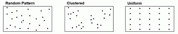
A full review of all methods for identifying spatio-temporal patterns is beyond the scope of this module. However, taking the example of point map layers, these points can represent the locations where a species has been identified as present (Perry, Miller and Enright, 2006), environmental hazards (e.g. floods, landslides, fires or lightning strikes), sites of historic importance (e.g. bedrock milling station locations where hunter-gatherers prepared food, Morgan 2009), or geomorphological features (e.g. dune crests – Wilkins and Ford, 2007). Point patterns can typically be described as having one of three characteristics: being uniformly distributed (or sometimes called dispersed), so the distance between points is unusually large; being randomly distributed, so the distance between points is similar to that for a set of points whose coordinates were generated randomly, or clustered, so the distance between points is unusually small.
An Example – Nearest Neighbour Analysis
Such patterns can be quantified using the nearest neighbour statistic which is calculated using the average distance from each point to its nearest neighbouring point. It then compares the computed average distance to a theoretical one that would be obtained if features were randomly distributed inside a circle with the same area value as the map layer of interest’s extent.
Spatio-temporal analysis of point patterns
Many of the point features described above can be described as events – in other words, they occur at a specific time or over a particular period. Thus, over a period of years, dune crests will move in response to wind climate; floods, fires, and landslides will occur at specific points in time; archaeological features will date from a specific period; and wildlife will be observed at a particular location at a particular point in time.
Time is often an important dimension of the patterns in such data, e.g. time of year when the transmission rate of a plant or animal disease is highest; diurnal movement of animals as their behaviour shifts from foraging to finding shelter; and seasonal peaks may occur in the frequency of environmental hazards. Techniques do exist for analysing patterns that take account of both the temporal and spatial dimensions. For example, the Knox test (Norstrom, Pfeiffer and Jarp, 2000) can be used to analyse spatio-temporal point patterns and identify points that are both close together in space and close together in time. However, at present such techniques are not yet implemented in ArcGIS. Given this situation, one way of working with spatio-temporal point data in ArcGIS is to sub-divide the data into different periods and then examine nearest neighbour statistics for each of these periods and how they change over time.
Activity
Practical exercise:
Point pattern analysis of contamination sites In this activity you can explore whether a spatial pattern exists in the location of known soil and groundwater contaminated sites in New Jersey by using the nearest neighbour analysis in ArcGIS. If you are using ArcGIS Desktop, please download this zip file with activity instructions and data. If you are using ArcGIS Pro, please download this zip file instead.
References (Essential reading for this learning object indicated by *)
Morgan, C. (2009) Climate change, uncertainty and prehistoric hunter–gatherer mobility. Journal of Anthropological Archaeology 28 (4), 382-396.
Nordstrom, M., Pfeiffer, D., and Jarp, J. (2000) A space–time cluster investigation of an outbreak of acute respiratory disease in Norwegian cattle herds. Preventative Veterinary Medicine 47 (1-2), 107-119.
Perry, G., Miller, B., and Enright, N. (2006) A comparison of methods for the statistical analysis of spatial point patterns in ecology. Plant Ecology 187, 59-82.
Wilkins, D., and Ford, R. (2007) Nearest neighbor methods applied to dune field organization: The Coral Pink Sand Dunes, Kane County, Utah, USA. Geomorphology 83 (1-2), 48-57.