5.3 Assessing landscape patterns
It is important for management purposes to understand how wildlife respond to their environment. If we alter the environment (through controlled burning or afforestation, for example), then this will have consequences for the animal species that live in it. However, when looking at the relationship between many animal species and their environment, it is clear that they do not respond to the presence or absence of a single vegetation community. For example, deer may require patches of woodland to provide cover during the day, but large areas of open grassland for grazing at other times. The deer will respond well to a suitable patchwork of woodland and grassland, but both vegetation communities need to be present to make an area habitable. Even if an animal only thrives within a single vegetation community, it is similarly important to know whether such patches of suitable habitat are distributed in small ‘clumps’ across an area or in a single large block. In order to assess the habitat preferences of such animals, we therefore need to describe the complex patterns formed by many different vegetation communities, instead of simply measuring (say) the percentage of forest cover in a given area. The discipline of landscape ecology has developed to deal with this issue. The discipline is now very broad and we provide only a brief introduction to it here.
A landscape is ‘an interacting mosaic of patches relevant to the phenomenon under consideration’
(Fragstats web site)
The central concept in landscape ecology is (unsurprisingly!) the landscape. In ecology, the scale of a landscape is defined relative to a given organism, so for a polar bear that ranges across a very large area, a landscape may be hundreds or thousands of kilometres across. For an invertebrate species such as a beetle, a landscape may only be several metres across. A landscape is made up of many different patches. A patch (see figure 1) is an area that is more or less homogeneous as far as the animal being studied is concerned. For deer, for example, all patches of vegetation dominated by bracken may seem more or less similar. Within some landscapes (but not all), there may be one particular vegetation community that dominates the landscape above all others, which is known as the matrix element. In a savannah, for example, this dominant element may be areas of open grassland, which form the greater part of the landscape.
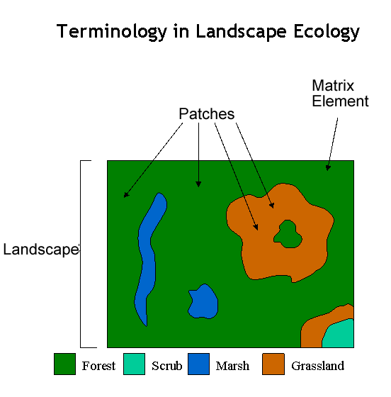
Figure 1: Terminology in Landscape Ecology
Patterns within a landscape can be measured at several levels. One option is to measure the characteristics of individual patches (see illustration below). Ecologists have long recognised that many habitats are subject to ‘edge effects’. For example, rodents living in a long, thin feature such as a hedgerow may be easily killed by predators since birds of prey will easily be able to access the edges of this feature. The centre of a more compact, rounded patch of shrub may be less susceptible to predators. Measuring the shape of individual habitat patches is therefore important.
Patterns can also be measured at the landscape level or for sub-divisions of the landscape. Many measures have been developed that assess the variety and abundance of different patch types within a landscape. For example, relative richness (see illustration above) measures the percentage of all the patch types available that are present in a given part of a landscape. Other landscape measures assess spatial configuration, such as the connectivity of a particular patch type. Connectivity describes whether patches of, say, marshland, are grouped close together (enabling migration of amphibians between them) or distributed evenly across the landscape (making migration of amphibians between them more difficult). In general, measuring spatial connectivity in a landscape is more difficult than measuring the abundance and variety of different patch types.
Activity
If you are using ArcGIS Desktop, download the zip file and undertake the activity described in the pdf file. If you are using ArcGIS Pro, download this zip file and undertake the same exercise. This involves measuring landscape patterns across the UK and examining their relationship with species of macro (i.e. large!) moth.
References (Essential reading for this learning object indicated by *)
* The most well-known software package in landscape ecology is FRAGSTATS. The FRAGSTATS web site contains an excellent introduction to measuring patterns in landscape ecology – follow the link to ‘FRAGSTATS documentation’ and then ‘background material’: http://www.umass.edu/landeco/research/fragstats/fragstats.html
The practical data are derived from two sources. The distributions of the peppered moth and brindled moth are derived from the MapMate Digital Atlas of scarcer Macro Moth species, copyright Biological Records Centre at www.mapmate.co.uk/downloads.html
The land cover data are derived from the public domain Countryside Information System software produced by the Centre for Ecology and Hydrology using the Land Cover Map of Great Britain 2000: http://www.ceh.ac.uk/services/land-cover-map-2000