6.5 Analysing Spatio-Temporal Data – Spatially distributed dynamic models
This part of the module investigates environmental models as implemented within GIS and considers how such models describe environmental processes over time. The term ‘model’ can mean many different things (references):
- A simplified, computer-based representation of real world characteristics as digital data. For example, a Digital Elevation Model is a simplified representation of the true shape of the earth’s surface.
- A conceptual understanding of environmental properties and their inter-relationships. For example, we might be convinced that a link exists between soil erosion and run-off, but be unable to quantify this relationship mathematically or statistically.
- A simplified mathematical or statistical representation of real world environmental processes. For example, we might relate tonnes of soil eroded to precipitation, slope, and vegetation cover.
In this object, we use the term ‘model’ in the latter sense – as a simplified mathematical or statistical representation of environmental processes.
There are many different methods by which the environment can be modelled. In a ‘lumped’ model, sections of the earth’s surface are modelled as a single homogenous entity. For example, a river catchment may be modelled in its entirety. Whilst such a model may include a parameter to represent the percentage of agricultural land within the catchment, it will not record whether this land is near the course of the river or far from its banks.
What is a spatially distributed model?
In contrast, a spatially distributed model breaks the study area down into separate ‘chunks’ and models each one separately. These chunks may be either pixels within a raster grid, points or areas or a map, or nodes and river stretches within a network. For example, a spatially distributed model of a river catchment might divide the catchment into pixels on a raster grid and model the flow of run-off over these pixels. Although many spatially distributed models are implemented within GIS, some are written using other software. For example, the SWARM modelling software can be used to produce spatially distributed models, but is not in itself GIS software.
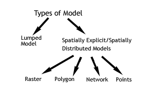
Figure 1: Types of model
Spatially distributed models allow for different levels of spatial interaction. In some cases, what happens in one pixel will not influence the model’s operations anywhere else in a raster grid. For example, the Universal Soil Loss Equation predicts the amount of soil eroded from vegetation, rainfall, soil type, slope characteristics and conservation measures. The equation is calculated separately for each pixel in a raster grid. What happens in any one does not influence what happens elsewhere and so there is no spatial interaction. In other cases, the model’s predictions in one pixel may influence what happens in immediately surrounding pixels. Thus, the appearance of bracken vegetation in a pixel in April may result in the vegetation of several surrounding pixels becoming bracken in May as succession takes place. This is an example of a model with a short-range spatial interaction. Finally, models may also have long-range spatial interactions. A hydrological model of run-off may evaluate the likelihood of flooding occurring during a storm event by dividing a catchment area up into pixels. For a pixel at the lower end of the catchment, the flow of surface water will depend on the many pixels that lie upstream – this is an example of a long-distance spatial interaction.
What is a spatially distributed dynamic model?
A spatially distributed dynamic model is one that explicitly represents environmental processes over time. A GIS-based model might use the Universal Soil Loss Equation to predict soil erosion in tonnes / hectare. If the model used only long-term average rainfall, it would be described as static, since it took no account of change over time. The soil loss model might be modified to vary over time, so that the amount of soil eroded was calculated every day, depending on daily rainfall totals. A more complex version yet of the soil erosion model might take account of the total tonnage of soil at the start of the model run and record the net balance of soil at the end of the model run. These last two model implementations would both be considered dynamic, since they explicitly handle the change in soil erosion over time.
Since most dynamic models divide time as well as space into manageable ‘chunks’, an important characteristic of such models is their time-step, whether this be hours, days or months. It should be borne in mind that many environmental models are developed using fine-scale data from field experiments, but run at much coarser scales. For example, a current major concern is the net amount of carbon dioxide exchanged between the atmosphere and different types of forest. This is important in understanding the climatic impacts of deforestation. Carbon dioxide is typically measured at different heights in the canopy using specialist equipment attached to scaffolding. These measurements are taken over an area of perhaps 5 by 5 metre and at a small number of sites. Scientists may then try to relate these measurements of carbon dioxide flux to factors such as rainfall, vegetation type or soil type, which can be mapped using GIS. In doing so, they can estimate the carbon dioxide fluxes areas such as the Amazon basin by combining the relationships found at their measurement sites with data in their GIS. However, the GIS-based data may be for months or years and apply to areas of 1 by 1 km, whereas the original field measurements may be hourly and for areas of 5 by 5 metres. There can thus be a problem in ‘scaling up’ the fine-scale field measurements using the coarse-scale GIS-based data.
There are now numerous Spatially Distributed Dynamic Models implemented within GIS such as:
- Markov chain models, which are often used to simulate changes in land cover (e.g. refer to the Idrisi manual for a description of Markov chains)
- Spatial meta-population models, which are used to simulate changes in animal populations within a landscape (e.g. see RAMAS-GIS),
- Individual-based modelling approaches, in which individual animals or people are represented within the model and respond to their surroundings (e.g. see SWARM)
A description of all of these model types is beyond the scope of this object. We will therefore consider just one type of environmental SDDM in more detail – cellular automata.
An example – cellular automata
Cellular automata are a way of modelling change over time dynamically by sub-dividing both space and time into discrete ‘chunks’. As described in the illustrations below, cellular automata operate on a uniform, regular lattice and are characterised by short-range spatial interactions. Following the concepts early beginnings in mathematics, GIS are now used as a source of data for cellular automata models of phenomena such as plant growth, vegetation succession, fire patterns, and land cover change.
Activity
Producing a spatially distributed dynamic model of soil water deficit
If you are using ArcGIS Desktop, download the zip file, which contains a precipitation time series for the Amazon basin. If you are using ArcGIS Pro, please download this version of the zip file and instructions. In this practical, you will produce a spatially distributed dynamic model of soil water deficit based on precipitation.
References (Essential reading for this learning object indicated by *)
* A useful starting point for reading about GIS and spatially distributed dynamic models is this article:
Giacomelli A (2005): Integration of GIS and Simulation Models. In Campagna M GIS for Sustainable Development, Taylor and Francis, London. pp. 181-190.
https://pdfs.semanticscholar.org/3ae1/d216bf8ffdc0fd74ba1165e8f45c9f549268.pdf
Several web sites include software that illustrates the ‘Game of Life’ and cellular automata, including this one: http://www.ibiblio.org/lifepatterns/
Elsewhere, there are numerous examples of spatially distributed dynamic models that can be used with GIS.
For example, the SWARM software has been used to model the spatial dynamics of red grouse and other animal populations: http://www.swarm.org/ (The main website is currently being rebuilt. Temporary site here)
The RAMAS software provides a way of modelling animal populations living in different patches within a landscape: http://www.ramas.com/
For further details of the model and data used in the practical, see:
Mali, Y. and Wright, J. A. (2004) Spatial patterns and recent trends in the climate of tropical forest regions. Philosophical Transactions of the Royal Society, Series B – Biological Science 359, 311-329.
New, M., Hulme, M., and Jones, P. D. (2000) Representing twentieth century space-time climate variability. Part 2: development of 1901-96 monthly grids of terrestrial surface climate. Journal of Climate 13, 2217-2238