New Discoveries at Ostia Antica and the Isola Sacra
The new discovery of extensive urban remains to the north of the river Tiber at Ostia Antica http://www.portusproject.org/blog/2014/04/new-city-wall-discovered-ostia/#.U063XyX5rTc.twitter highlights part of the survey project conducted between 2008 and 2012 across the Isola Sacra, the area of delta between Ostia Antica and Portus. The Isola Sacra, defined by the modern line of the River Tiber to the south and east, the Fossa Traiana to the north, and the Tyrrhenian Sea to the west, covers some 250 hectares, although the prograding nature of the Tiber Delta means that the ancient Roman coastline lies some 1.5km inland from its modern counterpart, reducing the area to 150 hectares.
The Isola has been a relatively unknown area relative to the sites of Portus and Ostia Antica. Although excavation of the Necropolis di Porto in the 1940s revealed the line of the Via Flavia connecting Ostia Antica with Portus, and tombs dating from the 2nd, 3rd and 4th centuries, the ‘sacred island’ has been the focus of scant investigation, beyond archaeological findspots and more recent investigation for mitigation works (see gazetteer in Germoni et al. 2011). Survey work between 2008 and 2012 focused on the production of a high resolution magnetometer survey of the landscape, covering most of the area between the ancient coastline, close to the line of the Via della Scafa, and the Tiber and Fossa Traiana. This survey was not a hunt for possible extensions of urban areas across the Tiber or the Fossa, but an attempt to understand the formation of this part of the delta in terms of geoarchaeological material, and the settlement and use of the zone, particularly for the Republican and Imperial periods, and the development of both Ostia Antica and Portus.
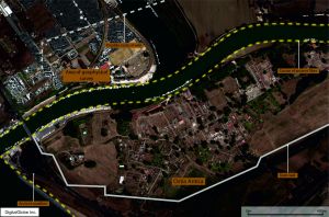
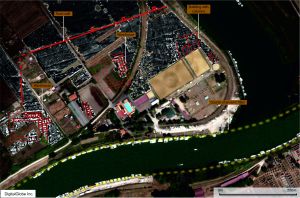
Results of the magnetometer survey in the southern part of the Isola Sacra. Satellite image courtesy of DigitalGlobe
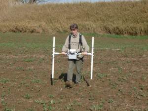
Seven seasons of survey work were conducted over the area, representing a massive effort by staff and students at the University of Southampton, the University of Cambridge and the British School at Rome, directed by Prof. Simon Keay and Prof. Martin Millett. Gridding and topographic survey was conducted with total station and RTK GPS, allowing the entire landscape to be gridded prior to the geophysical survey being conducted. Bartington Instrument fluxgate gradiometers were then used to survey across the landscape, covering an area of 150 hectares, to add to the 260 hectares covered at Portus in previous seasons, picking up on faint variations in the Earth’s magnetic field caused by buried archaeological deposits.
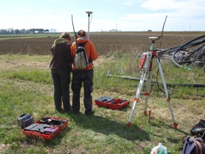
RTK GPS being used to survey in the vicinity of Ostia Antica by the University of Southampton and BSR team
The survey deepened our understanding of the complexity of archaeological deposits across the Isola, indicating the presence of significant waterways and canals associated with Portus and the Isola Sacra, together with a system of smaller canals for drainage and irrigation, or pre-Roman or Roman date. Compared with other data such as satellite imagery, a full assessment of the nature of archaeological features was conducted (Keay, Millett and Strutt 2014). In addition targeted use of geophysical survey methods has elucidated on the presence of archaeological remains, including the presence of Late Antique walls and structures close to the Episcopio near Portus, found during GPR survey in the area.
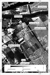
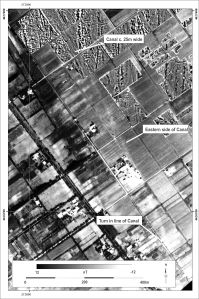
Image showing magnetometry results superimposed on Aereo Militare image from 1957, showing the presence of the canal traversing the Isola Sacra (from Keay, Millett and Strutt 2014)
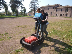
MSc students from the University of Southampton carrying out a GPR survey in the vicinity of the Episcopio, between Portus and the Isola Sacra
The results of the geophysics shows traces of the formation of the delta in the area of the Isola, including magnetic features associated with the prograding nature of the delta, and previous flow of the Tiber. This is particularly marked on the Isoal close to the Fiume Morto or ancient bend in the Tiber close to Ostia Antica. The significant canal that runs from Portus appears to run all of the way across the Isola, arriving close to the modern east – west course of the Tiber.
It is in this area that the substantial remains of an extension to the town of Ostia was found. The results indicate the presence of warehouses and large municipal buildings, some measuring 140m by 80m in length and breadth. The structures are enclosed by the line of a large defensive wall, with rectangular towers, each measuring 8m across.
The findings of the urban area are exciting in their own right. However what is more edifying is the relationship between this area and the surrounding hinterland of this complex port system. Beyond the gates of the city lies a landscape of fluvial and canal features linking the wetland of the delta, with its salt pans, fields and marble marshalling areas, with the River Tiber and the surrounding settlements and farms of the Tiber Delta. The results of the survey present an image of a complex and nuanced port and fluvial system, requiring considerable further analysis to understand the full significance of the delta area in relation to its principal urban areas and the surrounding landscape.
Press Sources
References
Germoni, P., Millett, M., Keay, S. And Strutt, K. 2011, The Isola Sacra: reconstructing the Roman landscape. In Proceedings of the Portus Workshop, March 3rd 2008, Rome.
Keay, S., Millett, M. and Strutt, K. 2014, The Canal System and Tiber Delta at Portus. Assessing the Nature of Man-Made Waterways and their Relationship with the Natural Environment . In Journal of Water History, 6, 1, 11-30.

