Blog Catch-up #2: Archaeological Survey at Buraimi Oasis
Having spent the day at British Museum a few Saturdays ago during the Seminar for Arabian Studies (https://www.thebfsa.org/) reminded me that we had conducted a survey at Buraimi Oasis earlier in the year. A paper was given on the results of the survey and the overall fieldwork, conducted by Zayed University, Abu Dhabi (http://www.zu.ac.ae/main/en/), ADTCA (http://tcaabudhabi.ae/en) and Sultan Qaboos University (http://www.squ.edu.om/) in Oman, by Dr Tim Power of Zayed University. I was involved in conducting the topographic and geophysical survey at the Oasis, and this seems like a good opportunity to put up a post on the work.
Buraimi Oasis is located in the north of Oman, forming part of an oasis group spanning the border between Oman and Abu Dhabi. The archaeology of the region is rich, including Palaeolithic, Bronze Age, Iron Age, Early and Late Islamic archaeology. The earliest dated feature in the vicinity of the survey area is the so-called ‘Qaṭṭara Tomb,’ which lies immediately adjacent to the UAE border fence close to Buraimi. and dates to the Wadi Suq period (c. 2000-1300 BC). Pre-Islamic settlement and material at the oases includes material at Qaṭṭara potentially dating to the Parthian period. The Early Islamic landscape of the Oases is marked by a series of falaj providing irrigation to the area with associated settlement and scatters of Early Islamic pottery. In Buraimi Oasis a number of scatters of Early Islamic material have been noted, together with extant structural remains, with ceramics similar to those found elsewhere in the oases. Late Islamic archaeology of the oases is well-represented with continuation of the falaj system of irrigation and the presence of enclosed gardens.
More recent development in the area has led to the building of new houses, supermarkets and hotels, all of which are now encroaching on the incredible archaeology of the oasis. The Buraimi Oasis Landscape Archaeology Project (BOLAP) was established to research the archaeology of the oases and to highlight the need for conservation of the archaeological resource at Buraimi.

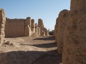
Tim Power and Peter Sheehan investigate Early Islamic building remains in the southern part of the oasis
A preliminary season of fieldwork was conducted at the oasis in the Spring of 2014, directed by Tim Power, and involving fieldwalking, trial trench excavation, together with topographic and geophysical survey. The combined results of the work were presented at the Seminar for Arabian Studies at the British Museum on 26th July 2014, and will appear in the next proceedings of the Seminar. The topographic and geophysical survey, however, provided excellent results with the palimpsest of archaeological material at the oasis visible in the data.
The survey areas were gridded out using an RTK GPS to position pegs at 30m intervals. The GPS was also used to collect spot height data across the different areas with which to build topographic models to compare with the geophysical survey results. Magnetometry and GPR survey were also conducted, with magnetometry being undertaken over all of the different sample areas, and the GPR survey being targeted over features of particular interest.
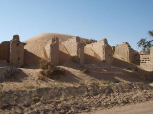
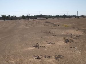
The nature of the archaeology can be seen on the surface of the ground across large parts of the oasis. A number of mounds with liberal scatters of Iron Age pottery are located in the area, and the Early Islamic and Late Islamic remains of enclosed gardens, buildings and the falaj irrigation systems can also be seen in part, indicating a complex system of habitation, land use and irrigation dating back thousands of years. The modern UAE-Oman border cuts across the oases, so many of the features visible at Buraimi continue on the other side of the border fence.
The results of the field season, and the topographic and geophysical surveys, indicate in part the phases of settlement across the survey areas, with walls, enclosures, falaj and other features clearly visible over what is now open terrain. The results of the survey, combined with air photographic imagery and the excellent results of the field surface collection and analysis conducted by Tim Power, Peter Sheehan and students from Zayed University, provide a layered dataset for analysis demonstrate the long and varied pattern of settlement in the oasis.
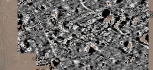
Detail of a small part of the magnetometer survey from Buraimi Oasis, showing the complexity and varied nature of archaeological features in the area
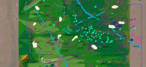
Detail of the interpretation of the same area, comparing the geophysics with the topographic survey results
Results of the survey really highlight the amazing preservation of parts of the oasis archaeology, but also helps to underline the threat posed to this resource from future development and the need for a conservation strategy. Fortunately, as could be seen from the paper given at the Seminar, nascent conservation plans are being considered, and hopefully future work at Buraimi will produce a comprehensive assessment of the state and nature of the archaeology.

