Theban Waterscapes and Harbours Survey THaWS 2014 – Measure for Measure
The current season of THaWS fieldwork has given the team some time for reflection on the survey results from 2012 and 2013, and has provided an opportunity for addressing some of the outstanding issues related to the mapping of Thebes on the west and east banks. Survey work throughout the 2012-2014 has been carried out by the team members, including the project director Angus Graham, who oversees the work with the Egypt Exploration Society (EES; http://www.ees.ac.uk/), Sarah Jones from the Museum of London (MOLA) and Dominic Barker and the author from the Department of Archaeology at the University of Southampton. In 2012, due to some problems with equipment, much of the surveying in of the geophysical survey areas and profiles was conducted using a total station. In 2013 an RTK GPS was used for surveying topographic points and giving elevation data for the topographic correction of GPR and ERT profiles. While these surveys gave sufficient data for processing and interpreting the results of the geophysics, it still left some largely unanswered questions in the minds of the team. How does the current GPS survey relate to the existing local surveys on the west and east banks at Thebes? What remaining survey markers or stations exist in the landscape, allowing THaWS to tie material in to the current survey? Most importantly perhaps, we returned to the issue of what elevation above sea level to use for the project. THaWS is interested in looking at the increasing levels of Nile sediment over thousands of years, and how the natural and man-made changes to the floodplain relate to the archaeology of the area. Having a standard benchmark or datum for this is crucial.

Assessing the different surveys and coordinate systems utilised around Thebes, using sketches and charts, the Survey of Egypt and Reimer maps and field notes
The first step in relating the different local surveys in the study area was to list and assess the nature of the different coordinate systems and datums utilised by different surveys.
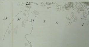
It is good to give a bit of historical background to the mapping in the area. The data that we have relate ostensibly to national mapping programmes, or individual projects utilising local or arbitrary coordinate systems. We also have mapping dating from the 19th century, in the form of sketch maps and plans. Of these the map data that has provided the most relevant data is the map produced by John Gardner Wilkinson (1797-1875). Wilkinson published The Topography of Thebes and General View of Egypt in 1835, describing the monuments and landscape around Thebes. No graticule is present on the map, and no information regarding datum or coordinate system are presented. The map does, however, relate standing archaeological remains with features on the Nile floodplain, and therefore provides a crucial document in building up a picture of the study area.
The maps that are perhaps most pertinent to the THaWS work are those produced by the Survey Department between 1892 and 1907 for the cadastral mapping of Egypt. Lyon’s 1908 description of the cadastral survey includes some notes on technical aspects of the survey, including the use of metal chains and some of the practicalities of surveying this vast country. The maps based on the Survey of Egypt for Thebes all utilise the Egyptian Red Belt datum and the Survey of Egypt coordinate system. These systems were also adopted by the map produced by Schweinfurth, published by Reimer in Berlin in 1909, and drawing on Wilkinson’s map, the Survey of Egypt cadastral survey.
One of the principal aims of the 2014 survey was to try and locate trig points and bench marks created by the Survey Department for the cadastral mapping of Egypt. Locating the remaining markers is, however, another matter. The reconnaissance in 2013 and this season has found only two markers; one a trig point above El Gorn on the heights above the Valley of the Kings, and a benchmark on the corner of the wall of one of the alabaster shops to the south of Hatshepsut. The lesson from this experience is clear: the survival of even official survey markers in the landscape at Thebes is unlikely.

Survey marker on the heights of Biban el Muluk, one of the only markers in the area of El Gorn where the marker survives
In addition to the national and regional mapping projects being assessed, many of the local surveys on the east and west banks are of relevance to the project. In particular survey of markers from the Theban Mapping Project (http://www.thebanmappingproject.com/) and markers from the ongoing project work at the temple of Amenhotep III provide useful ancilliary data for the THaWS work. These surveys use their own local coordinate systems, however, the use of reduced heights above sea level for the projects makes the survey of points vital to allow current survey data to be related to existing publications showing the relationship between monuments and the ancient Nile flood levels.
Survey this season with the GPS allowed a transformation to be performed between the UTM 36N coordinate system with WGS84 datum being used by the GPS, and the Theban Mapping Project survey markers. The result of this shows some large error caused by the probably moving of survey markers within the landscape over the last 20-30 years. The systems of these projects give useful elevation information that is germain to the aims of the current THaWS work.

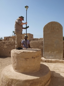
Dominic Barker and Kamal Helmy Shared positioning the GPS rover on a survey marker at the temple of Merenptah
One final set of survey data has been essential for resolving the issues surrounding elevation: the survey datum and account of Hölscher for the excavations at Medinet Habu. A datum point, set at 0m, was established by Hölscher on the threshold of the first pylon at Medinet Habu. He wrote:
‘For the leveling of Medinet Habu the threshold of the first pylon was chosen as the zero-point. This point lies 77.09 meters above sea-level. A bench mark of the Survey Department on top of the granite threshold between the two guardhouses of the Eastern Fortified Gate stands at +76.82 meters, that is, 27 centimeters lower than our zero-point of leveling.’
(Hölscher 1934, 3)
Although the Survey Department benchmark is no longer visible, the stones on either side of the central axis at the threshold remain in situ, and provided a useful datum to record with the GPS. In fact when this point is considered together with the other points of elevation on the West Bank there is a discrepancy of 0.12m over points spread some 5km across the landscape, a considerable achievement in terms of the accuracy of the original Survey Department benchmarks and the traversing of these elevations to the different projects concerned. For the THaWS survey we are now in a much better position to use a suitable benchmark for elevation above sea level that relates to the work and published material of the different projects at Thebes.
There is still work to do in relating our survey data with work on the West Bank and at Karnak to ensure that THaWS data is compatible with other datasets, in terms of spatial location and elevation. However, the relationship between our geophysical survey and borehole data, our current survey, and its relationship to other survey data at Thebes, is perhaps more transparent and congruent to existing material.
References
Hölscher, U. 1934, The Excavation at Medinet Habu. Volume 1 General Plans and Views. The University of Chicago Oriental Institute Publications Volume XXI. Chicago; University of Chicago Press.
Lyons, H.G. 1908, The Cadastral Survey of Egypt 1892-1907. Cairo; National Printing Department.
Wilkinson, J.G. 1835, Topography of Thebes and General View of Egypt, being a Short Account of the Principal Objects Worthy of Notice in the Valley of the Nile. London; John Murray.


