Guest Blog: Will Heard – Spring 2013 Survey Results Part 1
As part of the Spring Survey that the University of Southampton students carried out this April-May, undergraduate Archaeology students who attended the fieldwork were asked to write a report summarising the survey data.
One of the students that attended the Spring Survey, Will Heard, has written a summary of his report, and has kindly allowed us to share it with our readers. Will has written so much, that we’re sharing part 1 this week, and part 2 next week!
Thanks Will!
—
Basing House Spring Survey Part 1
by Will Heard, 2013 Will is a third year undergraduate student, with interests in survey, geophysics and the use of computers for archaeological purposes. He is interested in any period of history, having worked at Basing House and on a Bronze Age site amongst others. He is currently working on his undergraduate dissertation, which aims to use GIS systems to reveal the theoretical effectiveness against invasion of a small section of the World War II G.H.Q Line in Essex.Survey Summary
During March and April 2013 a topographic and geophysical survey was undertaken at Basing House by University of Southampton staff and students. Most of the topographic survey was carried out in week one between the 18th and 22nd March, while all of the geophysical survey was carried out in week two, between the 8th and 12th April. The work aimed to further the understanding of the sites layout and history by providing a computer model which will allow more detailed analysis of the landscape, and possibly help us see things our naked eyes cannot. The model will consolidate much of the smaller scale on site investigation (excavations, geophysics) which have been carried out and documented in the past. Similarly, future work of all types will be able to use the model to add onto a coherent body of knowledge. The geophysical and building survey, which was carried out alongside the topographic work, will add to this body of knowledge on Basing House.
Introducing the Site
The area has a long history with the earliest known finds dating from the Mesolithic era, although this occupation is not currently seen as continuing, since Neolithic remains are rare to nonexistent on the site (English Heritage 2004). Bronze Age flint, as well as Iron Age and Roman ceramics have also been recovered (English Heritage 2004). The most discussed period of the sites history starts in the Medieval period, with the construction of the Motte and Bailey castle (see central round and plateau like feature in figure 1) and later the Old and New Houses (inside and to the east of the motte in figure 1). The Motte and Bailey were erected sometime in the twelfth century AD and the Old and New Houses erected one after the other in the sixteenth century AD. The New House merited its own earthworks to the east of the Motte and Bailey and later, semi-circular Civil War gun platforms were added onto the earlier Medieval outer bank to the south. After the Civil War the houses were demolished, with much of the stonework taken and used in the nearby village. Other features include a dry and filled in part of the eighteenth century Basingstoke Canal (north edge of figure 1).

Figure 1 – OS Map data with a polygon overlaid (red line). The polygon represents the extent of the area surveyed topographically. ArcGIS 10.1.
© Crown Copyright/database right 2013. An Ordnance Survey/EDINA supplied service.
Below, figure 2 shows the areas that were surveyed with resistivity equipment. The contours in this figure are derived from a raster.
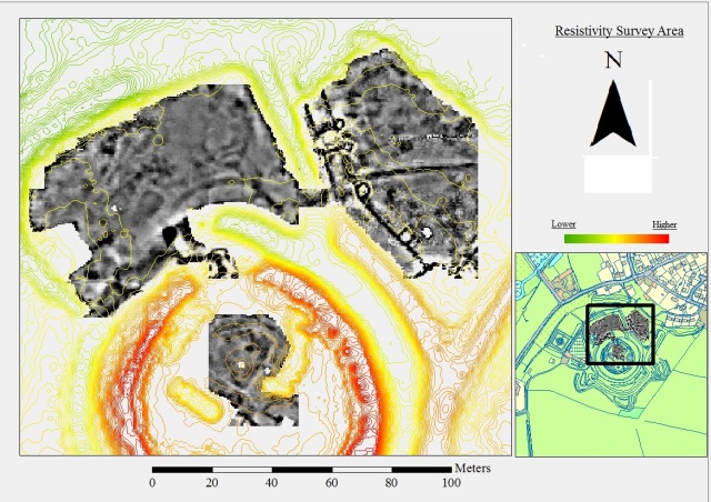
Figure 2 – The area surveyed with resistivity equipment (contours derived from a raster). ArcGIS 10.1.
© Crown Copyright/database right 2013. An Ordnance Survey/EDINA supplied service.
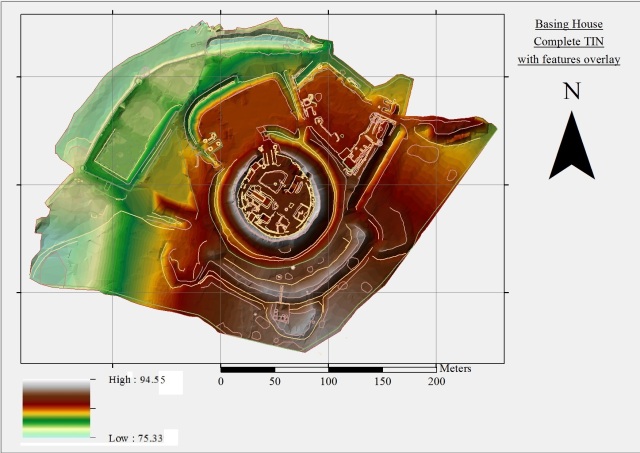
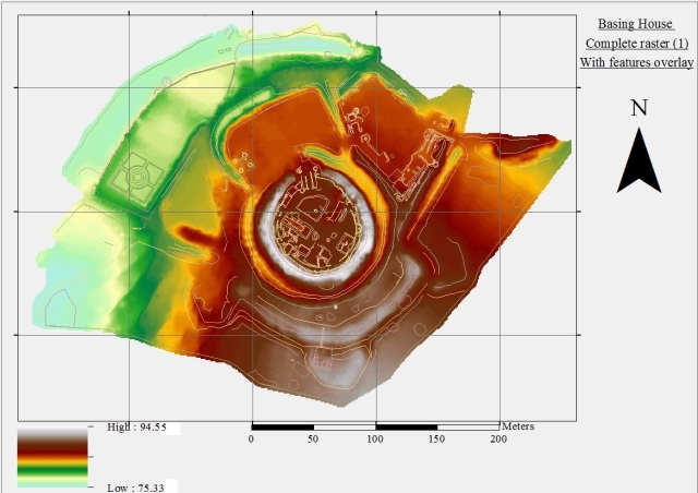
Since the survey produced one continuous area of data (see figure 3 and figure 4 below), the following pictures have some degree of overlap. The area has been split into four areas: A, B, C and D. The topographic areas B and C are the highlights included in this week’s blog post. In terms of the resistivity survey, the highlights were the Motte interior survey and the New House site survey.
Area B
Area B is the southernmost area surveyed and has the highest general elevation of any of this report’s areas. It comprises what is thought to be a long semi-circular bank that was possibly constructed at a similar time to the Motte and Bailey, as well as three Civil War raised gun platforms (English Heritage 2007a). These are clearly visible on the ground and are highlighted in figure 5. It is possible that the fact the three gun platforms are attached to the bank means that the bank was constructed earlier, since a connecting bank between Civil War gun platforms would not always be necessary. In the Civil War, the bank would have provided good cover against bombardment or assault from the south and so adding gun platforms to an already good fortification was the logical course of action. At points the ditch protecting the bank is deeper, for example at the westernmost end. Towards the southern end the ditch becomes very shallow. This variation is probably due to the natural topography, which gets higher as one goes further south on our model, this variation is highlighted in figure 6 below.

Figure 6 – Area B 3D TIN with features added. From the east. Light from the east at 45 degrees. Vertical exaggeration at 1.5. ArcGIS 10.1.
Area C
Area C is the centre of the topographic survey area and comprises the Motte, Bailey and their respective ditches. The elevation of this area is generally quite high, while being lower than Area B (see figures 7 and 8 below).
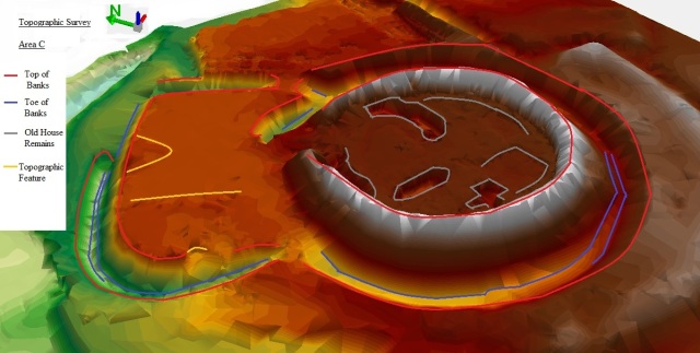
Figure 8 – Area C 3D TIN with features added. From the west. Light coming from the east at 45 degrees. Vertical exaggeration at 1.5.
The Motte and Bailey ditches are very deep, survive very well and show very nicely on the topographic models. All of the surviving cellars inside the motte lend support to Peer’s plan (figure 9 below).

Figure 9 – Plan of the Old House as excavated by Peers.
After (Royal Archaeological Institute 1924: 362).
The variations on the east side of the bailey are caused by a previous excavation that was carried out before a bridge over the ditch was constructed. The yellow line (north side of figure 8 above) represents a raised piece of ground and is the location of a large tree.
The topographic model shows the Motte being higher than the Bailey. This is to be expected, both because the land naturally goes down northwards, but also because the Motte was where the Lord would have resided.
The form of the Motte and Bailey is very similar to other examples like Launceston Castle (figure 10 below).
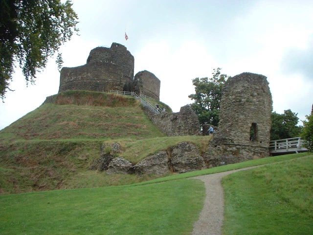
Figure 10 – Launceston Castle. In size, it is smaller than Basing House. However, its Motte and Bailey design is similar.
After (Wikipedia 2013)
References
Anon. (1924). Proceedings at Meetings of the Royal Archaeological Institute. The Archaeological Journal 81. Royal Archaeological Institute. 315-380. (Basing House pp. 359-364).
English Heritage (last updated 2004). National Monuments Record, Basing House. at: http://archaeologydataservice.ac.uk/archsearch/record.jsf?titleId=1033242; 27 Feb. 2013.
English Heritage. (2007a). Pastscape, Basing House at: http://www.pastscape.org.uk/hob.aspx?hob_id=240444; 01 May 2013.
Wikipedia. (2013). Wenesclaus Hollar – The Siege of Basing House at: http://en.wikipedia.org/wiki/File:Wenceslaus_Hollar_-_The_Siege_of_Basing_House.jpg; 6 Mar 2013.
Wikipedia. (2013). Launceston Castle at: http://en.wikipedia.org/wiki/File:Launceston_Castle_-_geograph.org.uk_-_22242.jpg; 12 Jul 13
Next Week: Part 2
In the next post, we’ll look at the results from the Motte resistivity survey and the New House resistivity survey.
Filed under: Spring Survey, Student Research Post, Will Heard Tagged: building survey, gpr, gps, ground penetrating radar, magnetic susceptibility, magnetometry, new house, old house, resistance survey, resistivity, survey, topographic, total station, undergraduate, will-heard

