1st March day off and visit to the Via Hadriana and quarries of Antinoupolis
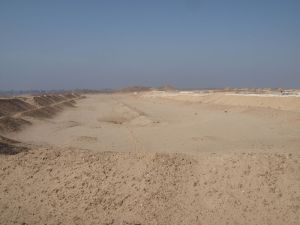
After another long week of survey, it was good to get out for a morning, away from the noise of Sheikh Ebada, and to have a look at the broader landscape of the ancient city of Antinoupolis. The planned itinerary was to walk up past the hippodrome, and along the wadi, finding the start of the ramp that leads to the Via Hadriana, the road linking Antinoupolis and the Nile with the Red Sea coast. The first part of the walk took me and Jay past the hippodrome, and we took some more photos showing the encroachment of the modern cemetery on the northern side of the sand bank of the structure.
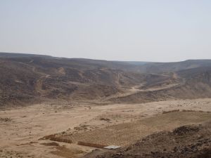
Beyond the hippodrome, the wadi which cuts the city runs from the north-east, and this is the line we followed up towards the plateaux and heights overlooking the city. The vast shape of a plateau, taking the form of the prow of a ship, is visible at the head of the main wadi, and it is to the top of this wadi that the Via Hadriana climbs.
Later in the day, we took a photograph from the hillside overlooking this plateau, and the starting point of the Via Hadriana was clearly visible, a ramp leading up from the wadi bottom, curving then turning and running onto the adjacent plain.
We followed the line of the ramp, looking in at some of the quarries that had undermined the road, and the shattered remains of collapsed rock lying in holes where the main roadway had fallen into the quarrying. As the road turned and headed to the north east, a final break in the route needed to be traversed, then the line of the Via Adriana spread out in front of us. The road at this point measures some 20m across. The plateau is covered by limestone blocks formed through natural processes, stretching as far as the eye can see, and the road was constructed by moving the stones to clear a route across t he plateau, marked by stones on either side.
We folowed the road for a mile or so, before turning back to cross the wadi to the west, and climb over to view Antinoupolis and the quarries above t he city. However the line of the Via Hadriana stretches across the bleak plain as far as the eye can see, tunring towards the west after a few miles, and disappearing in the belts of sand between fields of limestone blocks.
Our route took us back down the road and into the wadi, then up a steep scarp slope and on to the plateau to the west of the wadi between the Via Hadriana and Antinoupolis. Walking across the plateau, we eventually arrived at a shallow valley located above the main escarpment above the Nile valley, with surface and gallery quarries along the edges of the valley. We traversed this, walked over the next ridge and found ourselves overlooking the quarries of Deir El Sombat.
These immense gallery quarries provided some of the building stone for Antinoupolis. A Roman mud-brick structure is situated above the quarries at the southern end. The ridges in the distnce also show the black gashes of quarry mouths, with a watch station positioned above them, visible from many of the quarries. The different levels of the quarry mouths show the different strata of limestone being followed hundreds of metres below the plateaux. The final treat for me and Jay was to meet up with Rosario Pintaudi, Peter Grossmann and the Antinoupolis team to look inside one of the quarries. This contained the remains of a coptic rock-cut church.
The remains of the central apse are visible cut into the rock, and the remnants of mud-brick structure to the side indicates the remains of the church structure.
The visit and itinerary really helped to broaden our understanding of the aspects of the landscape around Antinoupolis. The importance of the city in a network of communication stretching to the Red Sea, an along the Nile valley is given particular emphasis. The quarries stretching for miles along the escarpment to the east of the city gives an idea of the sheer scale of the building project at Antinoupolis. The later habitation and places of worship of the coptic population, fitting considering the nature of the vast necropolis on the plain is also of interest. All of this insight will help with the ongoing survey work and the eventual interpretation of features in the data, and their relationship with the overall archaeology of the area.


