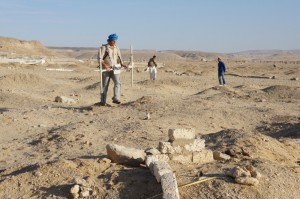
Antinoupolis Survey Magnetometry Commences
Trying to catch up with blog posts this week, on a slow internet connection and pushing the magnetometer survey forwards. Work is moving ahead with the survey of the necropolis of Antinoupolis. The area was gridded out last Saturday, with 10 hectares prepared, and the magnetometry has been moving forwards. The area in question is located between the north-western corner of the city, the Coptic cemetery to the west and the confines of the wadi to the north.
Areas of the cemetery were excavated by Gayet in the early part of the 20th century, and in these zones the terrain is difficult to walk, running between spoilheaps and the depressions left by the excavated tombs. Parts of mummified bodies and ceramics litter the ground. The mudbrick of the chambers and plinth tombs respond well to the magnetometry, against the ramla and sand of the wadi. So far a series of anomalies are visible, showing up an intensively populated area of tombs of all kinds.
In the process of reconnaissance of the site last week we visited the area of the main wadi which cuts through the ancient town from the vicinity of the hippodrome down to the course of the Nile. Some bulldozing has occurred here, and a number of stone blocks have been revealed in the centre of the wadi.
It is interesting to note that the ERT profile conducted in 2012 along the line of the Cardomaximus, and across the wadi, picked up a small high resistivity area which seemed to indicate masonry or building rubble in the centre of the wadi. A number of blocks in situ and redeposited seem to osuggest the presence of central plinths for bridges across the wadi, although the debate is currently ongoing about the nature of these structures.
The survey is continuing, trying to cover the areas of the necropolis close to the modern cemetery which is encroaching on the area. More news to follow hopefully with some more pictures!


