 Professor Tony Brown, Dr Thierry Fonville, Dr Ben Pears
University of Southampton, Tromsø Museum, UiT, University of Newcastle, Queen’s University Belfast
In conjunction with: Historic Scotland, Department of Arts, Heritage, Regional, Rural and Gaeltacht Affairs, Department for Communities
The AHRC funded Sea of Moyle Project aims to determine the relationships between historic sites and landuse on the Western Scottish and Northern Irish islands, from the early medieval to modern periods, to understand how populations were able to flourish from the individual community to inter-island network.
Small islands present us with the opportunity to study the sustainability and resilience of complex socio ecological systems over time. This project is investigating the changing landscapes, environment and population of a number of these islands in the Sea of Moyle over the last three millennia.
Today the area is seen as a remote border zone between Scotland and Ireland, in the past though the area was at times a coherent and central geographic region crossed by sea voyagers and linked by culture and kinship. With the expansion of Christianity, many of the islands saw the establishment of early Christian ecclesiastical sites and were within the over-Kingdom of Dalriada in the 6th to early 7thcenturies AD. The frequency and vulnerability of early medieval monastic sites across the Sea of Moyle was a driver to Viking Raids in the early 9thcentury AD, and by the mid- 9thcentury the Viking Kingdom of the Hebrides had been founded leading to the development of Scandinavian settlement across Suðreyjar, or “Southern Isles”. By the later medieval period Scandinavian influence slowly reduced with more control deriving from mainland Scotland and the eventual creation and development of the Lordship of the Isles, controlled from Finlaggan, Islay and lasting until 1493. The medieval and post- medieval periods saw significant expansion in population and anthropogenic influence in the agricultural landscape. Population densities fluctuated in the post- medieval and modern periods as a result of emigration and famine, leading to drastically underpopulated islands in recent times.
In general, the lack of modern intrusive population increase and intensive agricultural practice has resulted in the fossilisation and preservation of the historic landscape across many of the islands within the Sea of Moyle. Analysis of many of these microcosms with new analytical techniques, including sedaDNA, biomarkers, alongside traditional proxies will enable a richer understanding of the history of this dynamic seascape from the individual island to pan-European scale.
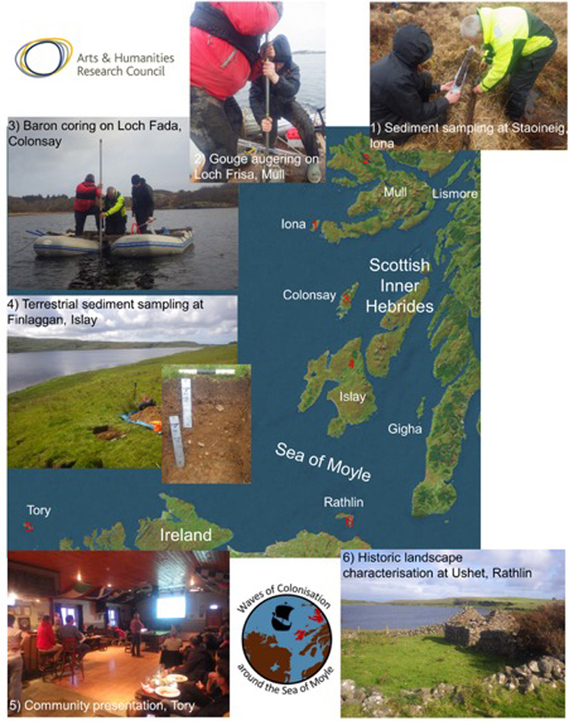
To date the project has seen extensive fieldwork across six islands in the Inner Hebrides of Scotland (Islay, Colonsay, Mull, Iona, Lismore and Gigha), and two Irish islands (Tory and Rathlin) off the northern coast. Between January to September 2019 each island was visited and detailed catchment assessments made of key freshwater bodies of water alongside detailed archaeological surveys.
Lake coring has been conducted at key sites to extract sediment sequences, and in most cases retrieval extended back to the beginning of the Holocene. In conjunction with the main cores water/sediment interface samples were also taken with Uwitech or Universal corers. Around the lakes terrestrial soil and sediment samples were taken at key landuse areas in order to determine the extent of anthropogenic influence in their creation, and to determine potential provenance for sediments within the lakes as well as the degree of soil erosion.
The project will now move into a phase of significant laboratory work, with further possible fieldwork planned for the middle of 2020. However important dissemination of the project have already been made at the Association of Environmental Archaeology (Nov 2018), and INQUA (July 2019).


