Sources of Topographic Data
This learning object provides an overview of sources of topographic data.
Topographic data can be obtained from a number of sources by using different types of sensors and data collection techniques. The most common sources are listed below:
- Photogrammetry: aerial or satellite sensor
- Laser scanner: space borne, airborne or terrestrial sensor
- Radar : aerial or satellite sensors
- Sonar: bathymetry
- From contours, other vector sources
Photogrammetry
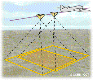
Elevation data obtained from photogrammetry is based on the principle of the stereo pair. In this case, the same area is captured in two images at slightly different view angles. Traditionally, these images were obtained from airborne platforms, however with recent development of imaging techniques we can obtain these images from satellite platforms. This provides the opportunity to obtain data for anywhere around the globe. The figure below shows the principle of stereo photo acquisition from an aerial platform. The central area of land is captured in two adjacent images, but will be viewed from different angles in each.
Laser Scanning
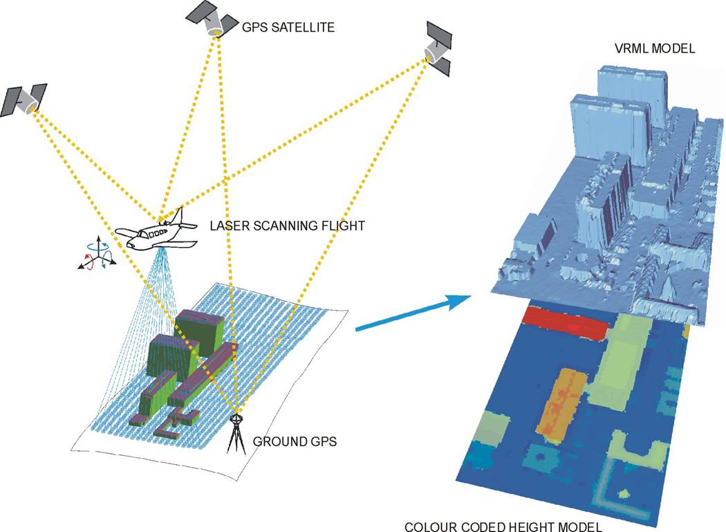
Topographic laser scanning is a relatively recent development since the invention of the laser in the 1960s. Terrestrial laser scanners based on tripods or vehicles are now widely used for topographic mapping applications. Laser altimeters have been mounted on airborne platforms since 1965. However until the 1990s with the development of airborne laser scanning mechanisms airborne laser scanners were limited to collecting data along a single line requiring multiple lines of flight to cover a large area. Laser scanning works on the principle of time of flight and measures the time difference between an emitted and received signal to estimate distance to surface, and thus elevation.
Radar
Radar uses the microwave part of the electromagnetic spectrum to acquire data. Elevation data from Radar are obtained through a process called interferometry. This is based on the analysis of the phase of the radar signal received by two antennae located at different positions. These instruments can be mounted on aircraft or on satellite platforms. NASA’s Shuttle Radar Topography Mission (SRTM), launched in February 2000, collected global elevation data using this technology.
Further Reading
The principles introduced here may contain several unfamiliar concepts and technologies. Students should make use of the following websites to augment their understanding of these topographic data sources.
LiDAR stands for Light Detection and Ranging. You can read about some real applications of LiDAR on the following two links:
http://grindgis.com/data/lidar-data-50-applications
http://www.lidar-uk.com/usage-of-lidar/
The following link provides further information on the principles of interferometry: http://www2.jpl.nasa.gov/srtm/instrumentinterfmore.html
Sources of global data elevation data
The following three data sources are most widely used global elevation data sets.
- Global 30 Arc-Second Elevation Data Set (GTOPO30)
- Shuttle Radar Topographic Mission (SRTM)
- ASTER Global DEM (GDEM)
GTOPO30 is the first global elevation data created from combination of several raster, vector layer and ground information. It has a spatial resolution of 1km and is provided by USGS.
GTOPO30: https://lta.cr.usgs.gov/GTOPO30
SRTM data, as mentioned before, are produced by space borne radar interferometry. It has a spatial resolution of 90m and is provided by USGS.
SRTM: SRTMhttps://lta.cr.usgs.gov/SRTM
ASTER global DEM is the most recent global elevation data produced from stereo pairs of satellite images. A total of 1.3 million satellite scenes were used to create the global database. It has a spatial resolution of 30m and is provided by NASA and Ministry of Economy, Trade and Industry, JAPAN.
https://asterweb.jpl.nasa.gov/gdem.asp
ALOS Global DEM: http://www.eorc.jaxa.jp/ALOS/en/aw3d30/