Data Acquisition Modes
The objective of this learning object is to introduce the idea that there are several different data acquisition modes possible in satellite photogrammetry and these have implications for accuracy, as measured by the Base/Height ratio.
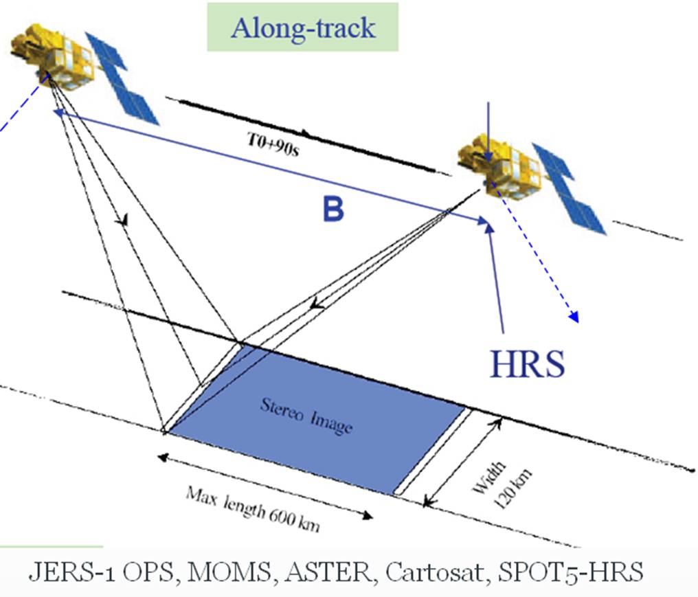
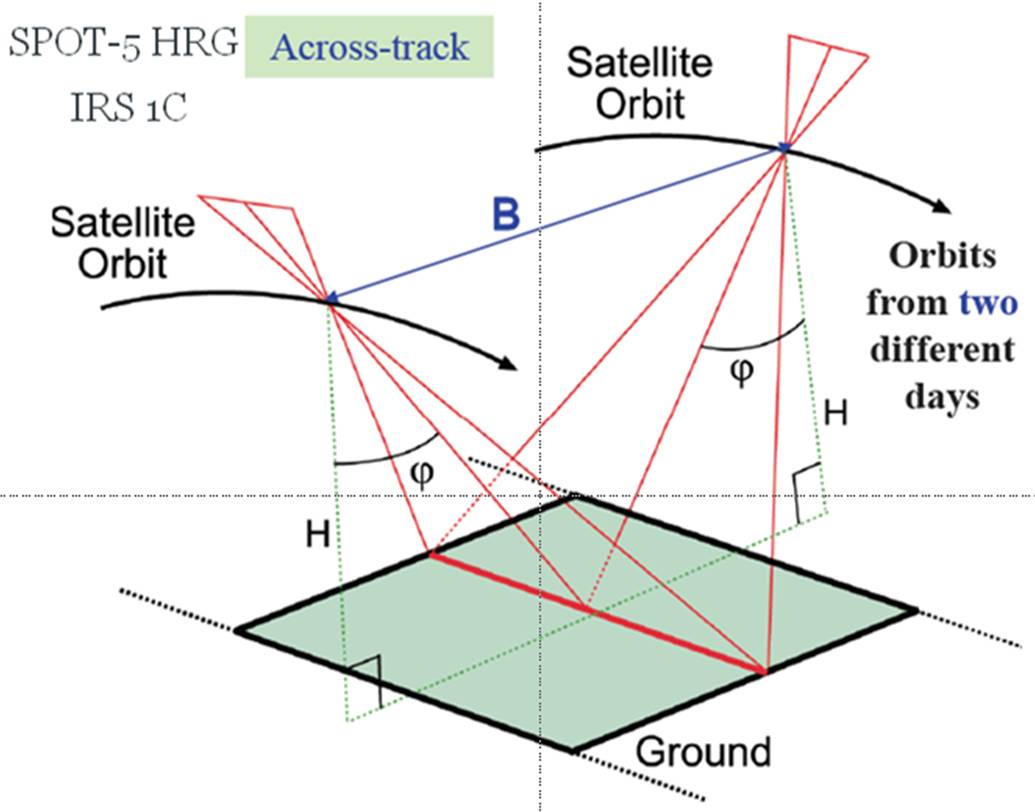
In the aerial system, images are captured along the flight line with endlap and sidelap using a single camera with a time delay. But in the satellite system it is not possible to get stereopairs in at one time because the images are captured line by line and there is no overlap between the lines (although conical look angle creates some overlap on the ground it is not differentiated at the resultant pixel). There are many possible ways to overcome this difficulty. One possibility could be to take images of the same area from two different angles (agile track). Another could be use two separate cameras in the same satellite, either facing along the path (along track) or across the path (across track). The following illustrations depict the different acquisition possibilities:
(a) Along track
(b) Across track
(c) Agile track
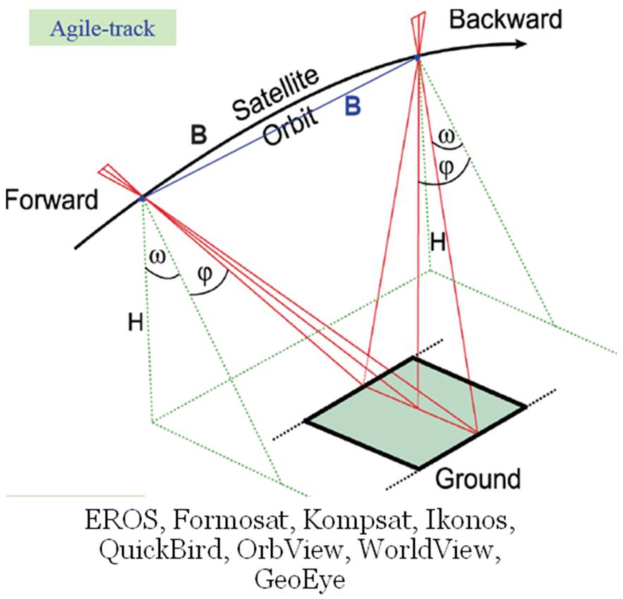
Source: Tautin & Staples (2009)
Reflection
Attempt to write a concise report (max two pages) on the potential advantages and disadvantages of each of the above systems. Click below for some example considerations.
A report of relevant issues should include the following (note that these are only examples, not an exhaustive list).
(a) Taking images from two different cameras would be a problem because of difference in the illumination conditions during the acquisition from these two cameras.
(b) If the two cameras are in the same sensor then how could the difference in their angle of viewing be determined? (This issue is discussed further below in the consideration of B/H ratio).
Incorrect
B/H Ratio
In the previous section and elsewhere, the relationship between focal length and flying height has been discussed. In the context of aerial photography, this was related to finding the scale of aerial images. In order to understand the quality of the digital elevation model (DEM) derived from photogrammetry, there is another measure called Base/Height ratio. In satellite-based photogrammetry, the Base/Height ratio is considered as the major criteria to describe the quality of the terrain information. The base refers to the distance between two camera positions and height refers to the satellite altitude. The following picture depicts different angles of view used for data acquisition:
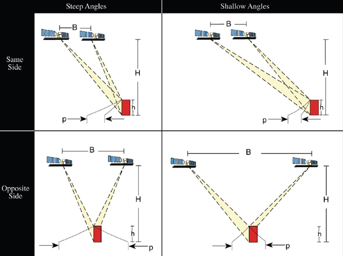
Strong intersection angle results in small uncertainty. B/H ratio between 0.6 to 1.2 is a typical value.
In the context of aerial photogrammetry, relief displacement varies with radial distance from the center of the photo. Hence, keeping the look angle steep would make the object displace more and hence introduce more error. Satellite viewing geometry is very complex and too much error of this type would make the rectification process cumbersome. Typically a B/H ratio between 0.6 and 1.2 is possible, and close to 1 is ideal.
Reflection
1. What happens to the errors in the computed positions and elevations if we increase the flying height (in a single image and in stereo images)?
2. What happens to parallax if base and height are changed (what is the relationship between parallax and accuracy)?
3. The same scale can be achieved when flying at different heights. How is this possible, and which is better – low fly or high fly?
Click below for links to references which help to explain these issues in greater depth.
Hasegawa, H., Matsuo, K., Koarai, M., Watanabe, N., Masaharu, H. and Fukushima, Y. (2000) DEM accuracy and the base to height (B/H) ratio of stereo images. International Archives of Photogrammetry and Remote Sensing. Vol. XXXIII, Part B4. Amsterdam http://www.isprs.org/proceedings/XXXIII/congress/part4/356_XXXIII-part4.pdf
Morgan, G.L.K., Liu, J. G. and Yan, H. (2008) Sub-Pixel Stereo-Matching for DEM Generation from Narrow Baseline Stereo Imagery Geoscience and Remote Sensing Symposium, 2008. IGARSS IEEE International III, 1284-1287 http://ieeexplore.ieee.org/stamp/stamp.jsp?arnumber=04779593
Incorrect