Recent Comments
Archives
Categories
- No categories
Meta
9. Earth Surface Properties
Objectives
The objectives of this section are to :
- Explore why we need to estimate earth surface properties
- Explain how to estimate terrestrial properties
- discuss the use of vegetation indices
Why do we need to Estimate Earth Surface Properties?
- To understand regional to global scale environmental phenomena
- Environmental degradation and climatic change have become major issues, especially because of the suspected role of human activity.
- The aim is to identify the nature, extent and severity of degradation processes to provide the necessary information to better manage the global environment.
An example:
N/B: The slides below will not show on the webpage, but you can save/keep them on your computer and view them using the Adobe Flash Player 32 you downloaded earlier
To estimate surface properties we have to take the data held in individual bands of the sensing device and process them to produce a measure of the physical property we are interested in. Typically we are interested in sensing land and ocean, within the land we are interested in sensing characteristics of vegetation, soil and snow.
Vegetation Properties
There are a number of vegetation properties that can give us useful information:
- Changes in global vegetation cover seasonally and over years
- Feeding into biogeochemical, climate and hyrologicial models
- The carbon cycle and its affect on biomass production
- Climate change detection , e.g. plant species advancing up mountains as they warm on average.
- Agriculture e.g. plant stress or harvest yields
To guage these properties we can measure the percentage vegetation cover, plant structure and pigment content (e.g. chlorophyll concentration).
Introducing Vegetation Indices:
Your eye samples in three bands; red, green and blue. It then combines them to produce a sensation of colour in your brain by combining information from the three bands. In remote sensing we can combine information from a number of bands mathematically to produce an estimation of things like chlorophyll concentration, these are known as indices.
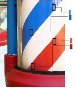
A vegetation index uses ratios to correct for different illumination amounts. To understand this consider the baber’s pole above, your perception of the red colour in the pole is that it remains constant all around the pole, even though the rectangles that have been cut out and copied show that the colour actually darkens to the left (cover up other parts of the image to remove your brain’s correcting effect and see it is true). That’s because your brain automatically compares colours in a scene, it notices the white turning more grey, the blue darkening and calculates (correctly) that the shade of red is not changing, its just that the left hand side of the pole is in more shadow.
Box photo courtesy of http://www.flickr.com/photos/henryleong/471922802/
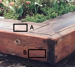
To extend the idea, consider the browns (made up primarily of red and green colours) in the box corner shown above, assuming the brown colour on all sides is the same then the red band measured by the camera at location A was more intense than in B because of the shadow. The green band at A was more intense than B by exactly the same amount because it was affected only by the shadow so the ratio of red to green bands remains the same and defines the shade of brown of the box.
So by using ratios in measuring vegetation we can remove effects of shadow or differences in illumination.
Reflection
Three measurements are made during a day:
- at midday
- midday plus one hour and at
- 15 minutes before sunset
on the reflectance of a patch of well trimmed grass. In which of the three measurements is the ratio rule we have just suggested least likely to hold and why? (hint, think of sky colour)
Show Answer