Recent Comments
Archives
Categories
- No categories
Meta
6.4. Further Satellite Systems for Earth Observation
Objectives
This learning object introduces the AVHRR, Envisat, Terra and Aqua satellite programs which provide further important data series for earth observation. It also provides links to additional satellite programs and sources of data. The focus of the material is on the ways in which the different sensor systems used provide data series with distinct characteristics.
1.Advanced Very High Resolution Radiometer (AVHRR)
AVHRR is a series of polar orbiting satellites managed by the USA’s National Oceanic and Atmospheric Administration (NOAA). The series has provided continuous data since 1979 with a spatial resolution of 1.1 km at nadir. This system was primarily designed for monitoring snow, water and atmosphere but has later been used for vegetation monitoring. The bands available are:
| Channel number | Wavelength (µm) | Typical use |
| 1 | 0.58-0.68 | Daytime cloud and surface mapping |
| 2 | 0.725-1.00 | Land-water boundaries |
| 3A | 1.58-1.64 | Snow and ice detection |
| 3B | 3.55-3.93 | Night cloud mapping, sea surface temperature |
| 4 | 10.30-11.30 | Night cloud mapping, sea surface temperature |
| 5 | 11.50-12.50 | Sea surface temperature |
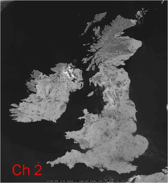
The image shows an example of AVHRR channel 2 covering the UK:
2.ENVISAT
The European Space Agency’s ENVISAT was the world’s largest satellite for environmental modelling. Launched on 1 March 2002 it carried 10 optical and radar instruments, including the MEdium Resolution Imaging Spectrometer (MERIS). However, the satellite was lost in April 2012. The MERIS sensor which was carried on board ENVISAT was a pushbroom imaging spectrometer which had 15 programmable bands in the region of 390-1040 nm and a 1150 km swath on the ground. Two spatial resolutions are available – full resolution (FR) of approximately 300m and reduced resolution (RR) of approximately 1200m. The instrument had a global coverage of every 3 days. A ‘continuation’ mission for MERIS i.e. ESA’s Sentinel-3 mission was successfully launched on the 16th February 2016- See section on Sentinel missions.
The following slide sequence illustrates typical MERIS settings for vegetation modelling and provides example MERIS imagery:
N/B: The slides below will not show on the webpage, but you can save/keep them on your computer and view them using the Adobe Flash Player 32 you downloaded earlier
3.EOS: Terra and Aqua satellites
These are the flagships of NASA’s Earth Observing System (EOS) of satellites. Terra was launched in December 1999 and Aqua in May 2002. Both have series of instruments to observe the total Earth system and the effects of natural and human-induced changes on the global environment. The sensor instruments carried are as follows:
| Terra | Aqua |
| ASTER | AIRS |
| CERES | AMSU |
| MISR | HRB |
| MODIS | AMSR |
| MOPITT | MODIS |
| CERES |
The Moderate Resolution Imaging Spectroradiometer (MODIS) is an instrument carried on both Terra and Aqua. It was designed to provide global observations of the Earth’s land, oceans and atmosphere. MODIS acquires data at three different spatial resolutions:
- 2 bands between .620 µm and .876 µm at 250m IFOV
- 5 bands between .459 µm and 2.155 µm at 500m IFOV
- 29 bands between .405 µm and 14.385 µm at 1km IFOV
thus providing 36 spectral bands in total. The data swath is 2330km.
4.Copernicus European Space Agency Sentinel Missions
The European Space Agency (ESA) has commissioned a new family of satellites which started to be launched in 2014 under the programme Copernicus Sentinel missions. There will be a total of six Sentinel missions(i.e. Sentinel 1 – 6). The Sentinel missions are based on constellation with each mission having two satellites. This approach will result in data at high spatial and temporal (revisit time) resolutions. The Sentinel missions carry a number of instruments including radar and multispectral imaging systems for land, atmospheric and ocean monitoring. Below is a brief description of the Sentinel missions:
- Sentinel 1: This mission carries radar instrument and is capable of imaging in all weather conditions, both day and night. Sentinel 1A was launched on 13th April 2014 and Sentinel 1 B was launched on 25th April 2016.
- Sentinel 2: This mission carries a multispectral high resolution imaging camera. It is essentially used to monitor land(e.g. providing information on vegetation, soil and water cover and coastal areas). Sentinel 2A was launched on 23rd June 2016 and Sentinel 2B on the 07 March 2017.
- Sentinel 3: This is a multi-instrument mission similar to how ENVISAT (See Figure 6.1 below). It is designed to monitor sea-surface topography, sea and land surface temperature, ocean and land colour, Sentinel 3A was launched on the 16th February 2016, and Sentinel 3B is set for launch in 2018.
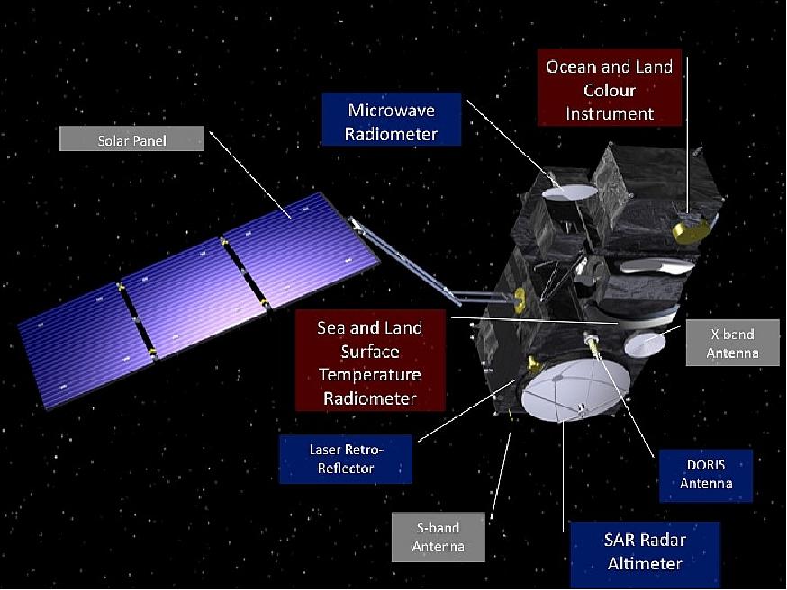
Figure 6.1: Sentinel-3 instruments.
- Sentinel 4 and 5: will carry instruments used to monitor atmospheric conditions.
- Sentinel 6 : will carry a radar altimeter to monitor sea surface height.
For more information on the Sentinel missions, including band specifications visit: http://www.esa.int/Applications/Observing_the_Earth/Copernicus
5.Other satellites/data sources
References
There is a wide range of resources which provide further details of all these satellite programs and sensor systems, with most of the principal systems having extensive websites of their own:
DIGITALGLOBE, 2008, Quick bird http://www.digitalglobe.com/
ESA, 2008. The ERS Instruments. https://earth.esa.int/web/guest/missions/esa-operational-eo-missions/ers
ESA, 2008. Envisat Instruments. https://earth.esa.int/web/guest/missions/esa-operational-eo-missions/envisat
NASA, 2008. MODIS Web. http://modis.gsfc.nasa.gov/
NASA, 2008. TERRA: The EOS flagship. https://terra.nasa.gov/
NOAA, 2008 Advanced Very High Resolution Radiometerhttps://earth.esa.int/web/guest/missions/3rd-party-missions/current-missions/noaa-avhrr
Townshend, J.R.G. and Tucker, C.J. 1984. Objective assessment of Advanced Very High Resolution Radiometer data for land cover mapping. International Journal of Remote Sensing, 5, 681-698.
Tucker, C.J., Townshend, J.R.G. and Goff, T.E. 1984. Continental land cover classification using meteorological satellite data. Science, 227, 369-375.