Recent Comments
Archives
Categories
- No categories
Meta
6.1. Overview of Satellite Systems
Objectives
The objective of this unit is to introduce some of the principal spaceborne remote sensing systems and their key characteristics. This unit provides an overview of how we get data from satellites and the remaining learning objects in the unit describe important satellite systems which provide widely-used remotely sensed data.
How do we get Satellite Data?
The operation of the satellite is managed by a control centre (1) which communicates with a signal receiver on the satellite (2). The scanner (3) captures remotely sensed data and this is transmitted to a ground receiving station (4). Data received is subject to pre-processing (5) and onward transmission (6) to a storage centre (7), from which it can be distributed to users (8).
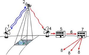
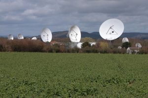
Left: system for receiving data from satellite; Right: Madley Satellite Earth Station (Image source: Geograph.org.uk © Copyright Philip Halling and licensed for reuse under this Creative Commons Licence)
It is therefore apparent that obtaining satellite remotely sensed data requires a complex series of supporting technologies to be in place, including a spacecraft mission to launch a satellite platform carrying an appropriate sensor device into orbit. Many satellites do not carry remote sensing devices but are intended for entirely other purposes such as communications relay or Global Positioning System satellites intended to assist with Earth surface navigation. Remote sensing satellites have often been operated as part of long-running programs intended to ensure that new satellites are launched to replace earlier ones carrying similar sensors and thus to provide continuity of data streams for end users and their applications. There is of course a tension between providing continuity of sensors devices and thus data, and providing more advanced sensors which provide more detailed data which is not directly comparable to that which was previously available.
Data recorded by satellites may be (A) directly transmitted to Earth; (B) recorded on board the satellite or (C) relayed through the Tracking and Data Relay Satellite System (TDRSS). This is a NASA communication relay system which provides links between low earth orbiting satellites and the ground, increasing the proportion of their orbit over which which they can remain in data communication. TDRSS satellites remain in geostationary orbit and relay communications between remote sensing satellites and ground terminals.
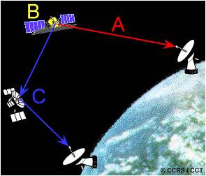
(Image source: CCRS)
There are many satellites orbiting the Earth. The figure varies, but it is estimated that there could be over 6,000 satellites of various types orbiting the earth.
| On orbit | Decayed | Total | |
| All | 3,375 | 2,971 | 6,166 |
| CIS | 1,414 | 1,889 | 3,303 |
| US | 1,078 | 755 | 1,833 |
| Japan | 122 | 20 | 142 |
| PRC | 80 | 47 | 127 |
| ITSO | 64 | 1 | 65 |
| GLOB | 60 | 0 | 60 |
| France | 47 | 9 | 56 |
| ESA | 47 | 7 | 54 |
| Germany | 36 | 13 | 49 |
| India | 39 | 9 | 48 |
| ORB | 41 | 0 | 41 |
| UK | 27 | 9 | 36 |
(CIS: Commonwealth of Independent States – former USSR; ITSO: International Telecommunications Satellite Organization; GLOB: Globalstar; ORB: ORBCOMM)
Activity
To accompany this unit, students should use one of the recommended textbooks to develop their general understanding of the principal remote sensing satellite systems:
Campbell, J. B. and Wynne R.H. (2011) Introduction to Remote Sensing, Fifth edition, Taylor and Francis, London. (Chapters 4, 6, 7 and 8).
Lillesand, T. M., Kiefer, R.W. and Chipman, J. W. (2015) Remote Sensing and Image Interpretation, Seventh edition, Wiley, Chichester. (Chapters 5, and 6)
Mather P.M. and Koch, M(2011) Computer Processing of Remotely Sensed Images, Fourth edition, Wiley and Sons, Chichester. (Especially chapters 2).
Considerable information on new and proposed sensors is available on the internet, for example, http://www.esa.int/Our_Activities/Observing_the_Earth/Copernicus/Overview4