Recent Comments
Archives
Categories
- No categories
Meta
12.1. Hazards, Disasters, Flooding and Earthquakes
A rapidly developing area of study in disaster management is the use of volunteered geographic information (VGI). The following video (https://www.youtube.com/watch?v=fJvR84UX5RI#t=81) is presented by web GIS experts who believe they are part of a paradigm shift in how disasters are dealt with. I believe there are reasons to be more critical of the potential of VGI in Haiti than the presenters would have you believe but it still represents a very interesting, developing area of study.
Activity
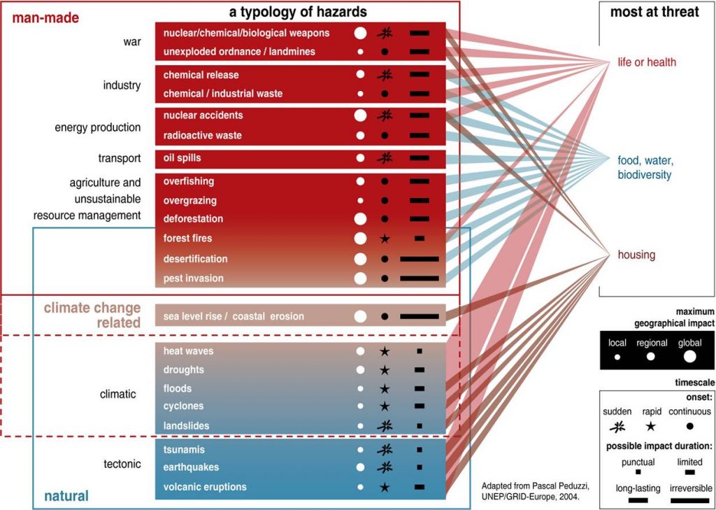
Taking the following hazards;
- War
- Industry (e.g. chemical release)
- Energy production (e.g. radioactive waste)
- Transport (oil spills)
- Unsustainable resource management (e.g. overfishing)
- Climatic (e.g. floods)
- Tectonic (e.g. earthquakes)
identify a] if they are man-made, natural or both b] if they are local, regional or global
Show Answer
Natural Disaster Management
Disaster management can be split into 2 activities;
- Response and Recovery: Reacting to the immediate effects of a disaster and then returning the community to normal.
- Mitigation and Preparedness: Minimising the effects of a hazard and planning how to respond to a disaster
These are ideals, for example very often disasters occur in areas that are unprepared e.g. the Haitan earthquake of 2010 occurred in a country ravaged by civil war and corruption.
Remote sensing can be of use:
- Identifying areas of potential exposure to natural hazards
- Identifying areas affected by the natural disaster
- Finding suitable sites of rehabilitation (e.g. identifying areas for refugee sites)
- Planning to tackle future disasters (Plans for evacuation, choice of roads etc.)
Activity
Suggest how useful remote sensing could be for three of the seven types of hazard identified above for the two disaster management activities identified above. Then think of more general reasons that remote sensing is of use in a hazard or disaster situation.
Show Answer
Activity
Trends in Natural Disasters
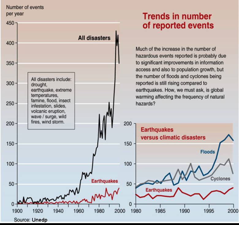
Reports of natural disasters have increased in recent time, this is down to two main factors; the rise in the world population and improvements in reporting but also global warming is increasing the hazards from weather events. Using the graph above, how could you estimate the effects of these two factors on meterological events in the period 1980 to 2000?
Show Answer
International Charter
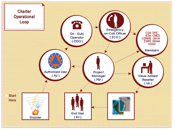
An international charter exists where space agencies controlling satellites can be called upon to rapidly acquire data relevant to an occurring/recently occurred disaster. The charter aims at providing a unified system of space data acquisition and delivery to those affected by natural or man-made disasters through authorized users.
Floods and Earthquakes
N/B: The slides below will not show on the webpage, but you can save/keep them on your computer and view them using the Adobe Flash Player 32 you downloaded earlier
References
Adams, B.J., 2004, Improved disaster management through post-earthquake building damage assessment
using multitemporal satellite imagery, Proceedings of the ISPRS XXth Congress Volume XXXV,
Must Read:
Karen E. Joyce, Stella E. Belliss, Sergey V. Samsonov, Stephen J. McNeill and Phil J. Glassey, A review of the status of satellite remote sensing and image processing techniques for mapping natural hazards and disasters, Progress in Physical Geography, 2009; 33; 183-207
National Snow and Ice Data Center resources for the Google Earth
Must Read:
David M. Tralli et al., Satellite remote sensing of earthquake, volcano, flood, landslide and coastal inundation hazards, ISPRS Journal of Photogrammetry and Remote Sensing,
Volume 59, Issue 4, 2005, Pages 185-198,