Recent Comments
Archives
Categories
- No categories
Meta
1.1. Course Overview
Welcome to Remote Sensing for Earth Observation! The course is intended to be a general introduction to remote sensing, covering the basic principles, major remote sensing systems, image processing techniques and application areas. Remote sensing is broad (as shown in Figure 1 below), but the focus of this module will be on terrestrial/land (rather than atmospheric or marine) applications.
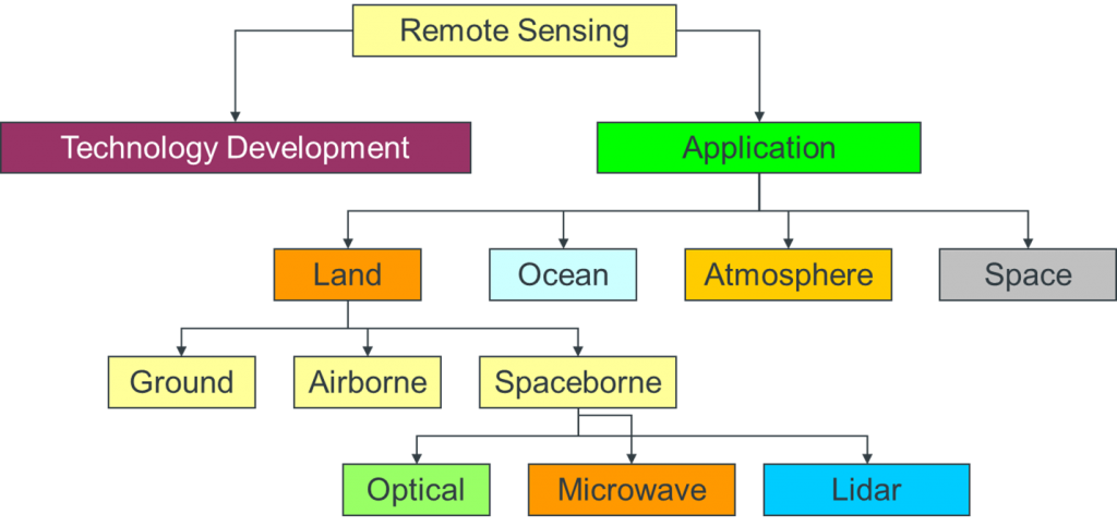
Figure 1. Branches of Remote Sensing
The materials that follow are made up of four main sections:
- Principles of remote sensing: We cover the basic principles behind remote sensing and the physical processes that determine what can and cannot be accomplished with the technology. In reality, the science underpinning remote sensing is quite complex, so in these materials, we present a somewhat simplified view on a ‘need to know’ basis.
- Sensors used in remote sensing: Here, we look at some of the systems that are most frequently encountered when undertaking terrestrial remote sensing in particular, such as the Landsat ETM and TM systems. We also introduce the general characteristics of the different types of remote sensing system. However, there are a great many remote sensing systems and there are many that we do not cover. As one example, the Defense Mapping Satellite Program (DMSP) includes sensors that have been used to detect artificial night-time lighting from human activity. Because this is an introductory course, we do not cover the DMSP system in our materials.
- Digital image processing techniques: Here, we look at some of the main ways of analysing remotely sensed imagery. We can distinguish pre-processing techniques – used to prepare an image for subsequent analysis – from methods used to generate data products such as classification and visual interpretation of digital imagery. Again, because this is an introductory course, we do not cover all of the techniques that are available. For example, we cover basic georectification techniques, which are methods for ensuring that the co-ordinate system in a digital image relates to a ‘real world’ co-ordinate system like latitude and longitude or Universal Transverse Mercator (UTM) coordinates. However, we do not cover orthorectification – more advanced techniques for reducing the geometric distortions caused by variations in the terrain within a sensor’s field of view.
- Applications of remotely sensed data: We focus particularly on terrestrial applications of remote sensing in this course. We take a particularly close look at land cover classification but also cover application areas such as natural hazards and disasters, ice-sheet monitoring, flood extent mapping, and public health applications of the technology. Once again, this is an incomplete picture of all of the application areas for the technology. There is an entire sub-discipline concerned with using remote sensing to map atmospheric composition (e.g. lower atmosphere particulate concentrations) and an entire sub-discipline concerned with oceanographic applications of remote sensing (e.g. sea height; sea surface temperature). Again, in the interests of brevity, we have focussed on a selected number of remote sensing application areas.
In short, it should be borne in mind that these are introductory materials with a terrestrial and largely 2-dimensional focus. This course is particularly concerned with land cover – understanding the physical properties of terrestrial surfaces, rather than their vertical profiles. A second companion module to this one focuses on the role of remote sensing in mapping 3-dimensional objects using technologies such as LIDAR (light detection and ranging).
Throughout the course, we have included both practical exercise based around the Envi (and occasionally Google Earth) software and other activities, which are a mix of quiz and short answer questions, calculations, and discussion topics. Unless explicitly stated, these activities are not assessed, but you are strongly encouraged to try out these activities as they should help to broaden your understanding of the subject.
We hope you enjoy the module and becoming familiar with the world of remote sensing.