
The Ground Based Observations for Validation (GBOV) project, was initiated by the European Commission’s Joint Research Centre (JRC) and provides multiple years of high quality in-situ datasets for the direct validation of seven of the Copernicus Global Land Service (CGLS) global bio-geophysical products. A team from Geography and Environmental Science at the University Of Southampton led by Professor Jadu Dash, have been focusing on the vegetation variables, namely leaf area index (LAI), the fraction of absorbed photosynthetically active radiation (FAPAR), and the fraction of vegetation cover (FCOVER), one of the key variables to understand biosphere-atmosphere interaction.
Part of this project focuses on the upgrading of existing field sites with new instrumentation to develop an automated collection of ground measurements for validation. Three sites were selected for vegetation validation sites:
- Hainich national park, Germany – a broadleaved deciduous forest
- Valencia Anchor Station, Spain – a Mediterranean crop site
- Tumbarumba, Australia – a broadleaved evergreen forest

In August 2019, Luke Brown and Harry Morris, researchers from the University of Southampton were involved in the installation of new equipment at the Hainich National Park field site.
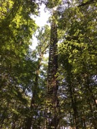
Located in the province of Thuringia, Germany, Hainich National Park forest is a prime example of a beech forest. In 2011, it was added to the Ancient and Primeval Beech Forests of the Carpathians and Other Regions of Europe a transnational composite nature UNESCO World Heritage site.
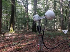
The first day of the field campaign was spent at the Department of Bioclimatology at the University of Göttingen. Before installing the Cyclapse timelapse systems at the field site the instruments were programmed to take images every 30 minutes during daylight hours and upload the data onto a remote server. In addition, the optical calibration of the DHP cameras was performed.
The next two days of the field campaign involved the installation of the DHP systems at the site with the help of researchers from University of Göttingen. The system was installed 130 m south-east of the flux tower at the centre of the field site. Throughout the rest of the trip, the team performed a mini field campaign collecting measurements of FAPAR and LAI from elementary sampling units (ESUs) across the field site. The instrumentation deployed will allow daily observations of the biophysical condition of the canopy, which can be used for the validation and calibration of numerous earth observation satellites.
Follow us on Twitter @ Copernicus_GBOV and online at https://gbov.acri.fr/