Interim Report 2013 – Geophysical Survey
This Interim Report will soon be available as a PDF on the Hampshire County Council website for Basing House.
The authors are:
David Allen
Gareth Beale
Nicole Beale
Chris Elmer
Jude Jones
Kristian Strutt
Clare Allen
Daniel Jones
There are three posts that make up this report. The post below describes the excavation and recording methodology and outlines the research question for the dig for 2013. Two further posts describe the finds and also the geophysical survey that was started in Spring 2013 and which continued through the Summer of 2013.
Part 3 – Geophysical Survey
– By Kristian Strutt and Clare Allen
The summer season of survey work was undertaken on Basingstoke Common, using GPS and Magnetometry. This survey work was part of an MSc dissertation and aimed to develop on the spring season of survey work. The main aim of the research was to examine the potential archaeology on the common and to assess the nature of these features through the use of geophysical survey. Using interpretation from previous survey results, an examination of aerial photographs and an analysis of the historical background of Basing House; the methodological approach to the survey was to use magnetometry. It was apparent that this technique would be suited to the potential nature of archaeology existing on the common. The site complex demonstrates a palimpsest of archaeology from prehistory to the English Civil War and 20th century wartime defences. With this in mind, it was possible to examine the defensive role of Basing House and its environs.
Magnetometer survey was carried out using a Bartington Instruments Grad 601 dual sensor fluxgate gradiometer. Readings were taken at 0.25m intervals along the traverses, with traverses spaced at 0.5m intervals. This technique was used to survey the site grounds and Basingstoke Common. This technique seemed most suited to both the environmental conditions and the potential nature of the archaeology at Basing House.
The results of the survey (see figures 2 and 3 below) indicated a number of archaeological features associated with the prehistoric, Civil War and 20th century defensive archaeology of the site. A ditch feature associated with the prehistoric or medieval settlement of the ridge is visible enclosing part of the common, running into the curtilage of Basing House and being cut by the Civil War defences. The half-moon earthworks of the Royalist defences show clearly in the magnetometry, including the ditch and possible remains of the palisades. The possible location of Parliamentarian siegeworks close to the site are, however, more difficult to trace. It is possible that the siegeworks are located along the line of the present hedgerow and fenceline, less than 30m from the defences of Basing House. The results of the survey did reveal the line of a substantial World War II anti-tank ditch, running from north-east to south-west across the common. This evidence is supported by air photographic evidence from the 1940s, indicating the defensive role of Basing House in the landscape surrounding the River Loddon. There remains scope for future geophysical survey at the site across the common and in areas surrounding Basing village, to help the team understand the buried archaeological deposits associated with Basing House.
You can click on the figures below to go to the Flickr page for the image, where larger versions are available.
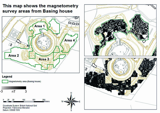
Figure 2 – This map shows the magnetometry survey areas from Basing House. Figure by K. Strutt and C. Allen, 2013.
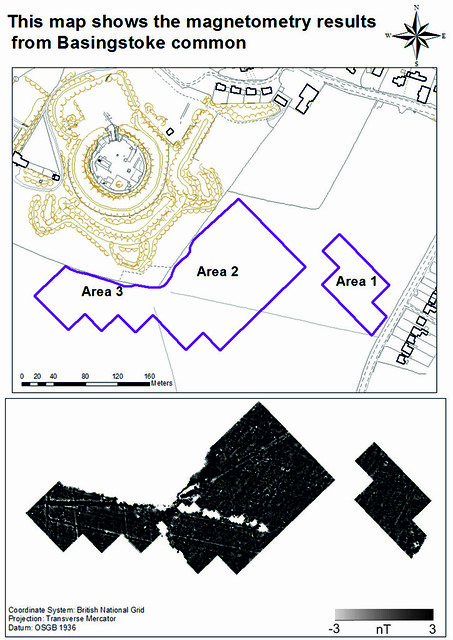
Figure 3 – This map shows the magnetometry results from Basingstoke Common. Figure by K. Strutt and C. Allen, 2013.
References
Allen, D., S. Anderson, 1999. Basing House, Hampshire. Excavations 1978-1991, Hampshire Field Club and Archaeological Society Monograph Series
Combley, R.C., J. W. Notman, H. H. M. Pike, 1964. Further Excavations at Basing House, 1964-66. Proceedings of the Hampshire Field Club. 23: 96-105
Peers, C., Sir. 1909. On the Excavation of the Site of Basing House, Hampshire. Archaeologia, Miscellaneous Tracts relating to Antiquity. London: Society of Antiquaries 61: 553-564
Read the previous posts of this Interim Report:
– Introduction and Recording Methodology
Filed under: Clare Allen, Geophysical Survey, Interim Report 2013, Kris Strutt, Magnetometry Survey, Spring Survey, Summer Excavation Tagged: 1940s, aerial photographs, anti-tank ditch, Bartington Instruments, basingstoke common, defenses, earthworks, gps, gradiometer, half-moon, interim report, magnetometry, Old Basing, palisades, river Loddon, survey, total station survey, World War II


