Survey and Excavation at Cranborne Chase
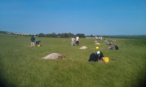
After a few weeks of survey in the New Forest, teaching of practicals and writing up of some papers, it was good this week to get back out in the field with staff and students from the University of Southampton. This time we headed out to Dorset for excavation and survey at Down Farm on Cranborne Chase, with teams of students involved in excavation, finds processing and recording, together with some topographic survey and magnetometry. weather during the course of the week was beautiful, strong sunshine with a light breeze moving over the hay meadows, with skylarks singing in the sky, reminiscent of surveys and excavations in the past on moorland in the north of England.
The group were divided into teams for excavating of 1m by 1m test pits along a low lying ridge to the south of the farm, with others excavating a larger trench with pit and postthole features. Some studetns also commenced surveying, with magnetometry being conducted in the area around the main trench. The ground offered perfect conditions, although generations of plough damage and truncation of the ploughsoil suggest that remains in the area may be quite ephemeral.
The pla nover the next week or so with the magnetometry is to cover as much of the southern part of the field as possible, mainly as a training exercise, but also to locate any other posssible features that might make useful targets for excavation. The trenches, supervised by Tim Sly, Dom Barker, Cat Cooper and Sam Giffiths are revealing features broadly Iron Age in date, mainly pits and postholes, vut directly into the natural chalk. There is, however, real scope for much more extensive geophysical survey and topographic survey across the landscape at Down Farm. Given the nature of archaeological remains and the underlying geology, similar to that of Tidgrove Warren Farm in Hampshire, large-scale survey would provide some solid foundation data for analysis and targeted excavation.
The excavations and survey will continue next week together with magnetic susceptibility survey to broaden the survey coverage using a lower spatial resolution of survey. Topographic survey started on Wednesday using Smartnet GPS. The cellphone coverage for the area was, however, insufficient for operating Smartnet, and on Thursday standard RTK survey was coducted. The trenches and topography for the area will be surveyed in using this.


