7.7 Assessing causality
The potential is high for drawing incorrect conclusions about how environmental exposure affects disease from GIS studies. This is both because of data availability and methodological problems in such studies. It is important to understand what potential problems may occur when assessing causality in spatial epidemiological studies of exposure, so that findings can be interpreted in an appropriately cautious manner.
There are potentially two mistaken conclusions that can be drawn about the relationship between an environmental exposure and a disease. Firstly, a GIS-based study can suggest that the environmental exposure affects the disease, when in fact it does not (a type I error). Alternatively, the GIS-based study can suggest that the exposure does not affect the disease, when in fact it does (a type II error).
The most common cause of a type I error (i.e. mistakenly finding a relationship between exposure and disease where none exists) is confounding. This occurs where an unmeasured factor affects disease risk and is also related to the exposure being studied. For example, a study of poor air quality might show a relationship between asthma and residence in inner-city areas with high traffic densities. However, if lack of exercise is a risk factor for asthma and fewer people in inner city areas exercise regularly, then this apparent relationship may be due entirely to spatial variation in physical exercise, not pollutants from traffic. In this instance, the group exposed to traffic air pollution is not comparable with the group who are not exposed to pollution because they differ in terms of their levels of physical exercise. The health effect is related to a different causal pathway altogether – physical activity, not inhaled air pollutants. Cross-sectional studies are particularly vulnerable to this problem and particular attention should be paid to the potential effects of confounding when interpreting cross-sectional study findings.
Another problem inherent in GIS studies of exposure is bias. There are two types of bias that affect GIS studies. Selection bias occurs where the subjects being selected for study are not drawn randomly from the population at risk. For example, if controls in a case-control study are selected randomly from healthy patients attending at a doctor’s surgery, this sampling strategy may give a biased picture of the population at risk. Young men in particular very seldom attend surgeries and so such a sample of controls could be biased away from this age cohort. Selection bias may well affect the findings of a study, but it is difficult to assess from the outset whether such bias will result in a type I or type II error.
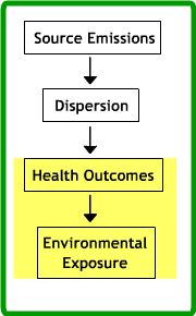
Accurate exposure measures are essential if the complex relationships between environment and health are to be understood.
(Briggs, 2000: p. 355)
The second type of bias is known as information bias. This occurs when the individuals being studied are mis-classified either in terms of their level of exposure or in terms of their health status. For example, a GIS study may measure exposure based on buffer zones around an incinerator chimney. If there are persistent winds in one direction, this buffer zone will under-estimate exposure downwind of the chimney and over-estimate exposure upwind of the chimney, so exposure mis-classification will occur. Health status can also be mis-classified. For example, many cancers have a latent period where they may remain undiagnosed. A case-control study may mistakenly include individuals with latent cancers in the healthy control group, thereby producing mis-classification of health status. In most situations, information bias will increase the chances of a type II error (i.e. not identifying a relationship between exposure and disease when in fact there is one), although there are specific circumstances where this is not the case.
The possibility that chance accounts for the study findings also needs to be considered. If the relationship between 10 different exposure measures and a health outcome is assessed statistically, it is quite likely that at least one of the exposure measures will appear significant at the 95% level. The possibility that an exposure-health outcome relationship is spurious should therefore also be borne in mind.
There are criteria for evaluating how far a GIS study of environmental exposure may have been affected by these problems, originally proposed by Bradford-Hill in 1965. Firstly, in interpreting the study findings, it is useful to consider whether there is a biologically plausible mechanism why the exposure might have led to the disease. For example, it is difficult to conceive of a mechanism for a significant spatial cluster of fall-related injuries among the elderly occurring near nuclear power plants. Secondly, it is worth considering whether several studies have drawn the same conclusions or whether the findings of the GIS study are completely at odds with previous research. Finally, the strength of the relationship in the GIS study between the environmental exposure and the disease should be considered. If the relationship is very pronounced, it deserves more attention. The latter two criteria form the basis of meta-analysis, a statistical technique for analyzing the findings of many different studies with similar designs.
Note: The slides below are missing the normal navigation bar for technical reasons linked to download time. Click on the presentation to move through the slides
Activity
Read the scenarios below which describe three different GIS-based studies of environmental exposures. Each study has encountered a methodological problem, which may have affected its findings. In each case, identify the type of methodological problem encountered (i.e. selection bias, information bias, or confounding) and suggest the likely effect on study findings (i.e. a Type I error, a Type II error, or potentially either of these). Post your answers to the course web site.
Scenario 1 – asthma and air pollution in China: A case-control study is taking place that assesses asthma in children in an inner city area of Beijing, China. The study is investigating the relationship between asthma and exhaust fumes from motor vehicles. Asthma sufferers attending health centres have been asked to complete a questionnaire, as have a similar number of healthy out-patients as a control group. Approximately 30% of the study participants could not be geo-coded because they either gave inaccurate or incomplete post codes on the study questionnaire. Geo-coding problems were much greater in the control group, where around 50% of the study subjects could not be geo-coded. The questionnaire data also suggest that the geo-referencing problems were greater among children from poorer, less educated families. What effect might these problems in geo-referencing study subjects have?
Scenario 2 – arsenic and drinking water in Bangladesh: Arsenic levels in water are a public health concern, particularly in Bangladesh , where the recent drilling of tubewells has produced water with very high arsenic levels (Hassan et al, 2003). High arsenic levels in tubewell water have led to high incidence of arsenicosis or arsenic poisoning, whose symptoms include skin discoloration and gastro-enteritis. Your GIS-based study aims to quantify the relationship between arsenic exposure and arsenicosis. You are assessing the prevalence of arsenicosis by bari (village) based on health centre records. The study aims to establish a relationship between arsenicosis prevalence and two variables:
- The number of tubewell users based on census data from 1998.
- Arsenic levels in tubewells as estimated from sub-surface geology (there is no widespread chemical testing of water sources throughout the country).
A civil engineer provides you with arsenic test results from water samples taken from 100 different tubewells. You compare the field test results to your estimated arsenic levels for these wells based on the local geology. You find that there is a significant but fairly weak correlation between the geology-based estimates & the arsenic levels in the engineer’s samples (r=0.6). You also learn from a social scientist that because of concerns about their health, since 1998 some Bangladeshis have started to use surface water sources such as rivers or streams instead of tubewell water. The surface water sources have negligible arsenic levels but often contain pathogens that cause diarrhea and cholera. What effects do you think these issues will have on the study?
Scenario 3 – breast cancer and pesticide exposure in the UK: Public concern has been expressed that pesticides are causing breast cancer (Kettle et al, 1997). You wish to evaluate this assertion through a study of pesticide exposure in Hampshire , UK . The study area contains a mixture of rural areas and urban settlements. You create a map layer depicting the spatial distribution of pesticide using field boundaries collected by the UK Department for Environment, Food and Rural Affairs. These data are combined with a database of pesticide spraying operations in 2001, referenced to each individual field. Notification of pesticide use by farmers has recently been made compulsory and forms the basis for the database. Breast cancer data for the year 2001 has been made available to you, which is geo-referenced using place of residence to census output areas. You also have counts of the total population at risk (women aged 15 years or over) in each output area from recent census data for 2001. By combining these data, you hope in your study to evaluate the relationship between age-standardised breast cancer incidence per census output area and exposure to pesticides. Exposure to pesticides will be measured based on the percentage of land sprayed in each output area.
The medical literature shows that obesity is a known risk factor for breast cancer. A separate study of Hampshire suggests that women living in rural and agricultural areas are likely to be more obese than those living in urban areas. How might this affect the findings of your study?
References (Essential reading for this learning object indicated by *)
This article provides an excellent overview of the general issues involved in interpreting epidemiological studies:
* Okasha, M. (2001) Interpreting epidemiological findings. StudentBMJ 9, 324-325. http://student.bmj.com/student/view-article.html?id=sbmj0109324
Briggs, D. J. (2000) Exposure Assessment. In Elliot P, Wakefield JC, Best NG and Briggs DJ Spatial Epidemiology: Methods and Applications. Oxford University Press, Oxford.
The three scenarios in the activity above are based on real-world GIS analyses. You can read more about these studies here:
Hassan, M. M., Atkins, P. J., Dunn, C. E. (2003) The spatial pattern of risk from arsenic poisoning: A Bangladesh case study. Journal Of Environmental Science And Health Part A-Toxic/Hazardous Substances & Environmental Engineering 38 (1), 1-24.
Kettles, M. A., Browning, S. R., Prince, T. S., and Horstman, S. W. (1997) Triazine Herbicide Exposure and Breast Cancer Incidence: An Ecologic Study of Kentucky Counties. Environmental Health Perspectives 105, 1222-1227. http://www.ncbi.nlm.nih.gov/pmc/articles/PMC1470339/
Levy, J. I., Houseman, E. A., Spengler, J. D., Loh, P., and Ryan, L. (2001) Fine particulate matter and polycyclic aromatic hydrocarbon concentration patterns in Roxbury, Massachusetts: A community-based GIS analysis. Environmental Health Perspectives 109 (4), 341-347 http://www.ncbi.nlm.nih.gov/pmc/articles/PMC1240273/