7.4 Ambient environmental monitoring
Ambient pollution monitoring is concerned with measuring pollutant concentrations in the general environment, rather than solely measuring emissions from sources. There are specific data quality issues and techniques associated with ambient pollution monitoring. It is important to understand these limitations when designing GIS studies of environmental exposure.
Problems with ambient pollution data
Most monitoring networks measure pollutant concentrations at only a small number of sites and consequently spatial interpolation is necessary to estimate exposures for populations lying between these monitoring sites. Frequently, however, finances for ambient monitoring networks are limited and locations of measurement sites may be determined by policy considerations. For example, a frequent configuration in surface water quality monitoring is to have measurement equipment immediately upstream and downstream of a discharge pipe. What problems might this cause when monitoring data are interpolated?
Answer 1
Whilst this is useful for monitoring emissions from a specific industry, such sample locations may be less useful for characterising typical concentrations of water-borne pollutants in a given area. By deliberately choosing sites near pollution sources, such monitoring networks may over-estimate overall pollution levels. Alternatively, if the monitoring network targets sites of high ecological value such as national parks, then pollutant levels may be under-estimated. Because monitoring sites are not chosen randomly, interpolation may produce a biased estimate of pollutant levels.
Hide
Monitoring networks may also be too sparse to adequately capture the underlying spatial variation in pollutant concentrations. For example, low-level ozone concentrations may be monitored at only a few monitoring sites within a city, yet ozone levels may vary markedly within a single block as a result of variations in traffic density and micro-climate. What problems do you foresee when the density of monitoring sites is low?
Answer 2
Insufficient monitoring sites can cause serious problems during interpolation. At best, spatial interpolation is likely to under-estimate the true degree of variation in pollutant concentrations, thereby leading to mis-classification of exposure status for the population at risk. At worst, the spatial variation in pollutant variations may be so great that it is impossible to estimate pollutant concentrations through interpolation.
Hide
How can you identify when there are insufficient monitoring sites to perform an interpolation? When using kriging, one approach would be to look at the shape of the variogram. A flat (100% nugget) variogram suggests a lack of spatial auto-correlation in pollutant levels and that interpolation would be inappropriate. Another technique for identifying when monitoring data are insufficient for interpolation is known as cross-validation. This is described in the illustrations below.
Techniques for ambient pollutant data
In the event that standard interpolation proves unreliable, one alternative to relying on routine monitoring networks is to develop monitoring networks that operate over shorter periods. Such monitoring networks can be designed to assess exposure within a specific target population group and often use low-cost technologies to monitor pollutant concentrations. One example of this was for the SAVIAH study, which used low-cost technology in Amsterdam and Prague to monitor nitrogen dioxide levels (Briggs et al, 1997).
A second possibility is to use additional information – such as traffic density or the presence of ecological indicators of air quality like lichens – to help guide the interpolation process. One statistical technique which makes use of such additional information is co-kriging. Co-kriging predicts pollutant levels at an unknown point based on measured concentrations at surrounding monitoring sites and using additional data, such as traffic density. An alternative approach is to statistically derive a regression equation that relates pollutant concentrations at monitoring sites to traffic density, land use and other available map layers (Briggs et al, 1997). The regression equation can then be used with the traffic density, land use and other map layers to produce a pollution map, a technique known as regression mapping.
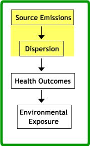
Finally, a third possibility is to use a dispersion model with source data to estimate pollutant concentrations. Any available ambient monitoring data can then be used to cross-check the results of this dispersion modelling.
Activity
If you are using ArcGIS Desktop, download the zip file and undertake the practical exercise, which involves developing a map of trends in sulphur dioxide concentrations using ambient pollution monitoring data from the USA . If you are using ArcGIS Pro, download this zip file and undertake the exercise looking at population exposure to fine air-borne particulates across London.
References (Essential reading for this learning object indicated by *)
This article describes a regression mapping technique for quantifying air quality. Note that you do not need to read the reference in order to complete the activity above.
Briggs, D. J., Collins, S., Elliott, P., Fischer, P., Kingham, S., Lebret, E., Pryl, K., VAnReeuwijk, H., Smallbone, K., and VanderVeen, A. (1997) Mapping urban air pollution using GIS: a regression-based approach. International Journal of Geographical Information Science 11 (7), 699-718
This site describes the use of lichens in modelling air quality : http://gis.nacse.org/lichenair/index.php