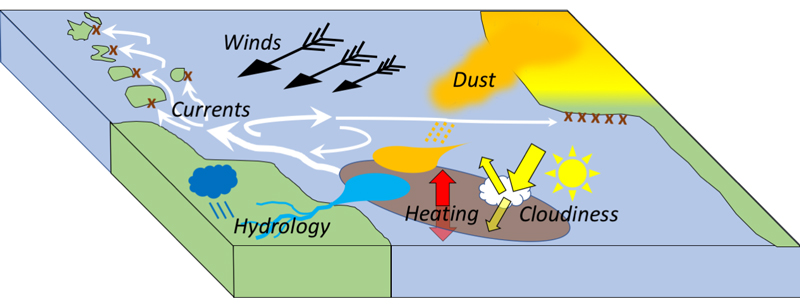
The macroalgae Sargassumgrows at the ocean surface, drifting with currents and winds. Mariners have long come across Sargassumin the subtropical Atlantic, but in 2011 large quantities showed up in the tropics. Since then, Sargassumhas proliferated, most notably in spring and summer, from the Gulf of Mexico, through the Caribbean, to west Africa. This natural phenomenon presents both environmental problems and opportunities to develop a new natural resource, across the region. The reason for this proliferation of Sargassumacross the tropical Atlantic are not fully understood, but multiple drivers are likely involved. Changes in the surface ocean and regional climate may have compounded changes in supplies of nutrients via the great rivers of South America or in dust blown from the Sahara. A more complete understanding of systematic environmental changes will inform regional adaptation to “Great SargassumBelt” as it most likely evolves over the next decade. At seasonal timescale, strong winds and swift currents drive Sargassum far and wide, to eventually beach throughout the Caribbean and along the shores of west Africa. With satellite-derived maps of “Floating Algae Index” to specify the distribution of Sargassumearly in the season, and with a detailed understanding of winds and currents, we can predict trajectories over many months, to predict the time and quantify beaching events at selected locations. These statistical seasonal predictions are complementing an embryonic Sargassumforecast system based on historical drifter data and operational ocean models, informing local adaptation and resource management.

